Marcyporęba geodata
Marcyporęba (Lesser Poland) is a populated place; located in Poland in Europe/Warsaw (GMT+2) time zone. With population of 960 people, there are 2570 cities with bigger population in this country. Compared to other cities in Poland, 85.8% of cities are located further ↑North; 51% of cities are located further ←West and 75.1% of cities have lower elevation than Marcyporęba. Note1


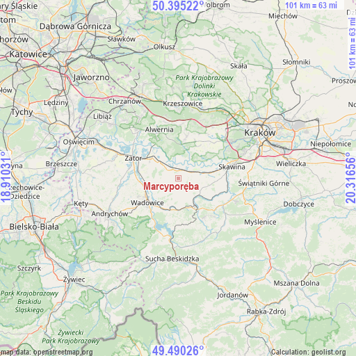
Marcyporęba GPS coordinates[2]
49° 56' 41.532" North, 19° 36' 48.348" East
| Map corner | latitude | longitude |
|---|---|---|
| Upper-left | 50.39522°, | 18.91031° |
| Center: | 49.94487°, | 19.61343° |
| Lower-right: | 49.49026°, | 20.31656° |
| Map W x H: | 100.6×100.6 km | = 62.5×62.5mi |
| max Lat: | 54.83135° ⇑85.8% North |
| Marcyporęba: | 49.94487° |
| min Lat: | ⇓14.2% South 49.21328° |
| min Long | Marcyporęba | max Long |
| 14.20249° | 19.61343° | 24.03723° |
| W 51%⇐ | ⇒49% E |
Elevation
Elevation of Marcyporęba is 247 m = 810 ft, and this is 55.6 m = 182 ft above average elevation for this country.
| Max E: |
974 m = 3196 ft | 24.9% |
| Marcyporęba | 247 m 810 ft | |
| Avg. | 191.4 m = 628 ft | |
Min E: |
-3 m = -10 ft | 75.1% |
See also: Poland elevation on elevation.city.
Geographical zone
Marcyporęba is located in North temperate zone (between Tropic of Cancer and the Arctic Circle). Distance of this North polar circle is 1847.8 km =1148.2 mi to North.| Distance of | km | miles | from Marcyporęba |
|---|---|---|---|
| North Pole | 4453.7 | 2767.4 | to North |
| Arctic Circle | 1847.8 | 1148.2 | to North |
| Tropic Cancer | 2947.4 | 1831.4 | to South |
| Equator | 5553.3 | 3450.7 | to South |


Nearby cities:
15 places around Marcyporęba: (largest is in red/bold)
• Brzeźnica
2.3 km =1.4 mi,  11°
11°
• Bęczyn
3.5 km =2.2 mi,  107°
107°
• Czernichów
6.9 km =4.3 mi,  44°
44°
• Paszkówka
4.7 km =2.9 mi,  98°
98°
• Pozowice
6.9 km =4.3 mi,  62°
62°
• Przytkowice
6 km =3.7 mi,  120°
120°
• Rusocice
5.7 km =3.5 mi,  355°
355°
• Ryczów
6.1 km =3.8 mi,  311°
311°
• Sosnowice
7.3 km =4.5 mi,  94°
94°
• Stanisław Dolny
5.3 km =3.3 mi,  147°
147°
• Stanisław Górny
3.9 km =2.4 mi,  162°
162°
• Witanowice
6.9 km =4.3 mi,  244°
244°
• Wysoka
4.3 km =2.7 mi,  189°
189°
• Zebrzydowice
7.4 km =4.6 mi,  144°
144°
• Łączany
5 km =3.1 mi,  330°
330°
Sources, notices
• [Note1] Compared only with cities in Poland existing in our database
• [Src1] Map data: © OpenStreetMap contributors (CC-BY-SA)
• [Src2] Other city data from geonames.org with taken over terms of usage.
• [Src3] Geographical zone / Annual Mean Temperature by Robert A. Rohde @ Wikipedia
