Brzeźnica geodata
Brzeźnica (Lesser Poland) is a populated place; located in Poland in Europe/Warsaw (GMT+2) time zone. With population of 1,281 people, there are 2102 cities with bigger population in this country. Compared to other cities in Poland, 84.6% of cities are located further ↑North; 51.2% of cities are located further ←West and 72.8% of cities have lower elevation than Brzeźnica. Note1


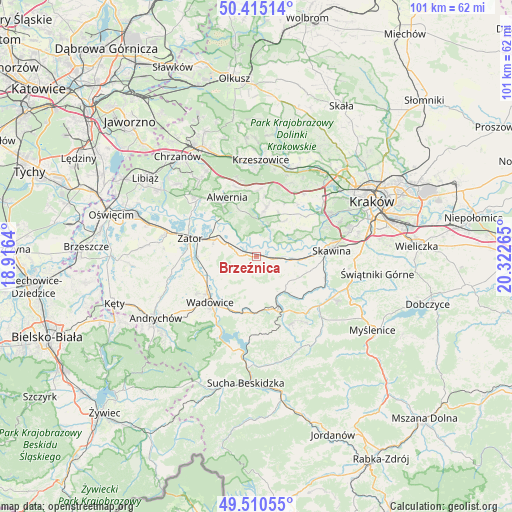
Brzeźnica GPS coordinates[2]
49° 57' 53.892" North, 19° 37' 10.272" East
| Map corner | latitude | longitude |
|---|---|---|
| Upper-left | 50.41514°, | 18.9164° |
| Center: | 49.96497°, | 19.61952° |
| Lower-right: | 49.51055°, | 20.32265° |
| Map W x H: | 100.6×100.6 km | = 62.5×62.5mi |
| max Lat: | 54.83135° ⇑84.6% North |
| Brzeźnica: | 49.96497° |
| min Lat: | ⇓15.4% South 49.21328° |
| min Long | Brzeźnica | max Long |
| 14.20249° | 19.61952° | 24.03723° |
| W 51.2%⇐ | ⇒48.8% E |
Elevation
Elevation of Brzeźnica is 239 m = 784 ft, and this is 47.6 m = 156 ft above average elevation for this country.
| Max E: |
974 m = 3196 ft | 27.2% |
| Brzeźnica | 239 m 784 ft | |
| Avg. | 191.4 m = 628 ft | |
Min E: |
-3 m = -10 ft | 72.8% |
See also: Poland elevation on elevation.city.
Geographical zone
Brzeźnica is located in North temperate zone (between Tropic of Cancer and the Arctic Circle). Distance of this North polar circle is 1845.6 km =1146.8 mi to North.| Distance of | km | miles | from Brzeźnica |
|---|---|---|---|
| North Pole | 4451.5 | 2766 | to North |
| Arctic Circle | 1845.6 | 1146.8 | to North |
| Tropic Cancer | 2949.7 | 1832.9 | to South |
| Equator | 5555.6 | 3452.1 | to South |


Nearby cities:
15 places around Brzeźnica: (largest is in red/bold)
• Bęczyn
4.4 km =2.7 mi,  138°
138°
• Czernichów
5.2 km =3.2 mi,  58°
58°
• Kamień
5.8 km =3.6 mi,  335°
335°
• Marcyporęba
2.3 km =1.4 mi,  191°
191°
• Paszkówka
5.1 km =3.2 mi,  124°
124°
• Pozowice
5.7 km =3.5 mi,  80°
80°
• Przeginia Duchowna
6.7 km =4.2 mi,  21°
21°
• Przeginia Narodowa
5.8 km =3.6 mi,  29°
29°
• Przytkowice
7.1 km =4.4 mi, 137°
• Rusocice
3.6 km =2.2 mi, 344°
• Ryczów
5.3 km =3.3 mi,  289°
289°
• Stanisław Dolny
7.1 km =4.4 mi,  160°
160°
• Stanisław Górny
6 km =3.7 mi,  173°
173°
• Wysoka
6.5 km =4 mi, 190°
• Łączany
3.6 km =2.2 mi,  306°
306°
Sources, notices
• [Note1] Compared only with cities in Poland existing in our database
• [Src1] Map data: © OpenStreetMap contributors (CC-BY-SA)
• [Src2] Other city data from geonames.org with taken over terms of usage.
• [Src3] Geographical zone / Annual Mean Temperature by Robert A. Rohde @ Wikipedia
