Witanowice geodata
Witanowice (Lesser Poland) is a populated place; located in Poland in Europe/Warsaw (GMT+2) time zone. With population of 1,162 people, there are 2243 cities with bigger population in this country. Compared to other cities in Poland, 86.7% of cities are located further ↑North; 50.7% of cities are located further →East and 83% of cities have lower elevation than Witanowice. Note1


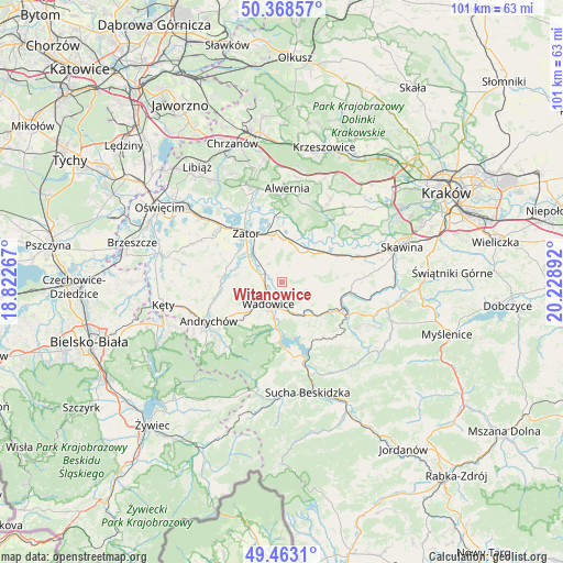
Witanowice GPS coordinates[2]
49° 55' 4.656" North, 19° 31' 32.844" East
| Map corner | latitude | longitude |
|---|---|---|
| Upper-left | 50.36857°, | 18.82267° |
| Center: | 49.91796°, | 19.52579° |
| Lower-right: | 49.4631°, | 20.22892° |
| Map W x H: | 100.7×100.7 km | = 62.6×62.6mi |
| max Lat: | 54.83135° ⇑86.7% North |
| Witanowice: | 49.91796° |
| min Lat: | ⇓13.3% South 49.21328° |
| min Long | Witanowice | max Long |
| 14.20249° | 19.52579° | 24.03723° |
| W 49.3%⇐ | ⇒50.7% E |
Elevation
Elevation of Witanowice is 280 m = 919 ft, and this is 88.6 m = 291 ft above average elevation for this country.
| Max E: |
974 m = 3196 ft | 17% |
| Witanowice | 280 m 919 ft | |
| Avg. | 191.4 m = 628 ft | |
Min E: |
-3 m = -10 ft | 83% |
See also: Poland elevation on elevation.city.
Geographical zone
Witanowice is located in North temperate zone (between Tropic of Cancer and the Arctic Circle). Distance of this North polar circle is 1850.8 km =1150 mi to North.| Distance of | km | miles | from Witanowice |
|---|---|---|---|
| North Pole | 4456.7 | 2769.3 | to North |
| Arctic Circle | 1850.8 | 1150 | to North |
| Tropic Cancer | 2944.4 | 1829.6 | to South |
| Equator | 5550.4 | 3448.9 | to South |


Nearby cities:
15 places around Witanowice: (largest is in red/bold)
• Bachowice
5 km =3.1 mi,  332°
332°
• Barwałd Dolny
6.6 km =4.1 mi,  150°
150°
• Chocznia
7.1 km =4.4 mi,  226°
226°
• Graboszyce
6.3 km =3.9 mi,  299°
299°
• Jaroszowice
6.2 km =3.9 mi,  184°
184°
• Klecza Dolna
4 km =2.5 mi,  167°
167°
• Klecza Górna
6.3 km =3.9 mi,  159°
159°
• Marcyporęba
6.9 km =4.3 mi,  64°
64°
• Radocza
3.6 km =2.2 mi,  269°
269°
• Ryczów
7.2 km =4.5 mi,  13°
13°
• Stanisław Górny
7.4 km =4.6 mi,  95°
95°
• Tomice
3.8 km =2.4 mi, 233°
• Wadowice
4.5 km =2.8 mi,  211°
211°
• Woźniki
3.3 km =2.1 mi,  311°
311°
• Wysoka
5.7 km =3.5 mi, 102°
Sources, notices
• [Note1] Compared only with cities in Poland existing in our database
• [Src1] Map data: © OpenStreetMap contributors (CC-BY-SA)
• [Src2] Other city data from geonames.org with taken over terms of usage.
• [Src3] Geographical zone / Annual Mean Temperature by Robert A. Rohde @ Wikipedia
