Wolbórz geodata
Wolbórz (Łódź Voivodeship) is a seat of a third-order administrative division; located in Poland in Europe/Warsaw (GMT+2) time zone. With population of 2,594 people, there are 1211 cities with bigger population in this country. Compared to other cities in Poland, 56.3% of cities are located further ↓South; 55.5% of cities are located further ←West and 50.2% of cities have higher elevation than Wolbórz. Note1


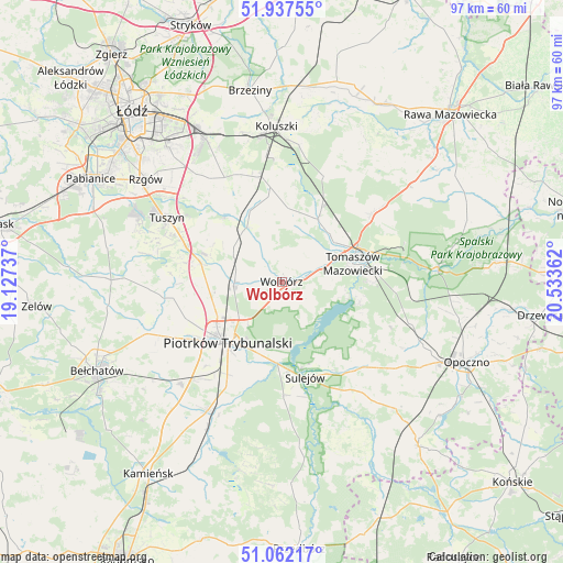
Wolbórz GPS coordinates[2]
51° 30' 7.056" North, 19° 49' 49.764" East
| Map corner | latitude | longitude |
|---|---|---|
| Upper-left | 51.93755°, | 19.12737° |
| Center: | 51.50196°, | 19.83049° |
| Lower-right: | 51.06217°, | 20.53362° |
| Map W x H: | 97.3×97.3 km | = 60.5×60.5mi |
| max Lat: | 54.83135° ⇑43.7% North |
| Wolbórz: | 51.50196° |
| min Lat: | ⇓56.3% South 49.21328° |
| min Long | Wolbórz | max Long |
| 14.20249° | 19.83049° | 24.03723° |
| W 55.5%⇐ | ⇒44.5% E |
Elevation
Elevation of Wolbórz is 171 m = 561 ft, and this is 20.4 m = 67 ft below average elevation for this country.
| Max E: |
974 m = 3196 ft | 50.2% |
| Avg. | 191.4 m = 628 ft | |
| Wolbórz | 171 m = 561 ft | |
Min E: |
-3 m = -10 ft | 49.8% |
See also: Poland elevation on elevation.city.
Geographical zone
Wolbórz is located in North temperate zone (between Tropic of Cancer and the Arctic Circle). Distance of this North polar circle is 1674.7 km =1040.6 mi to North.| Distance of | km | miles | from Wolbórz |
|---|---|---|---|
| North Pole | 4280.6 | 2659.8 | to North |
| Arctic Circle | 1674.7 | 1040.6 | to North |
| Tropic Cancer | 3120.6 | 1939.1 | to South |
| Equator | 5726.5 | 3558.3 | to South |


Nearby cities:
15 places around Wolbórz: (largest is in red/bold)
• Brójce
22 km =13.7 mi,  325°
325°
• Budziszewice
19.8 km =12.3 mi,  21°
21°
• Będków
11 km =6.8 mi, 329°
• Czarnocin
14.3 km =8.9 mi,  314°
314°
• Grabica
20.9 km =13 mi,  263°
263°
• Lubochnia
19.4 km =12.1 mi,  52°
52°
• Mniszków
20.6 km =12.8 mi,  135°
135°
• Moszczenica
7.7 km =4.8 mi,  270°
270°
• Piotrków Trybunalski
13.9 km =8.6 mi,  219°
219°
• Rokiciny
16.7 km =10.4 mi,  353°
353°
• Rokiciny-Kolonia
18.4 km =11.4 mi, 349°
• Sulejów
16.8 km =10.4 mi,  166°
166°
• Tomaszów Mazowiecki
12.7 km =7.9 mi,  75°
75°
• Tuszyn
24 km =14.9 mi,  299°
299°
• Ujazd
12.4 km =7.7 mi,  30°
30°
Sources, notices
• [Note1] Compared only with cities in Poland existing in our database
• [Src1] Map data: © OpenStreetMap contributors (CC-BY-SA)
• [Src2] Other city data from geonames.org with taken over terms of usage.
• [Src3] Geographical zone / Annual Mean Temperature by Robert A. Rohde @ Wikipedia
