Będków geodata
Będków (Łódź Voivodeship) is a seat of a third-order administrative division; located in Poland in Europe/Warsaw (GMT+2) time zone. With population of 550 people, there are 3408 cities with bigger population in this country. Compared to other cities in Poland, 57.6% of cities are located further ↓South; 53.7% of cities are located further ←West and 54.6% of cities have lower elevation than Będków. Note1


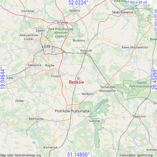
Będków GPS coordinates[2]
51° 35' 15.468" North, 19° 44' 58.416" East
| Map corner | latitude | longitude |
|---|---|---|
| Upper-left | 52.0224°, | 19.04644° |
| Center: | 51.58763°, | 19.74956° |
| Lower-right: | 51.14866°, | 20.45269° |
| Map W x H: | 97.2×97.1 km | = 60.4×60.3mi |
| max Lat: | 54.83135° ⇑42.4% North |
| Będków: | 51.58763° |
| min Lat: | ⇓57.6% South 49.21328° |
| min Long | Będków | max Long |
| 14.20249° | 19.74956° | 24.03723° |
| W 53.7%⇐ | ⇒46.3% E |
Elevation
Elevation of Będków is 184 m = 604 ft, and this is 7.4 m = 24 ft below average elevation for this country.
| Max E: |
974 m = 3196 ft | 45.4% |
| Avg. | 191.4 m = 628 ft | |
| Będków | 184 m = 604 ft | |
Min E: |
-3 m = -10 ft | 54.6% |
See also: Poland elevation on elevation.city.
Geographical zone
Będków is located in North temperate zone (between Tropic of Cancer and the Arctic Circle). Distance of this North polar circle is 1665.2 km =1034.7 mi to North.| Distance of | km | miles | from Będków |
|---|---|---|---|
| North Pole | 4271.1 | 2653.9 | to North |
| Arctic Circle | 1665.2 | 1034.7 | to North |
| Tropic Cancer | 3130.1 | 1945 | to South |
| Equator | 5736 | 3564.2 | to South |


Nearby cities:
15 places around Będków: (largest is in red/bold)
• Andrespol
17.3 km =10.7 mi,  334°
334°
• Brójce
11 km =6.8 mi,  320°
320°
• Budziszewice
15.6 km =9.7 mi,  55°
55°
• Czarnocin
4.7 km =2.9 mi,  275°
275°
• Gałków Duży
16.6 km =10.3 mi,  354°
354°
• Gałków Mały
15.5 km =9.6 mi, 350°
• Koluszki
17.5 km =10.9 mi,  16°
16°
• Moszczenica
9.6 km =6 mi,  192°
192°
• Rokiciny
7.9 km =4.9 mi,  27°
27°
• Rokiciny-Kolonia
8.9 km =5.5 mi, 15°
• Tomaszów Mazowiecki
19 km =11.8 mi,  109°
109°
• Tuszyn
15.4 km =9.6 mi, 279°
• Ujazd
12 km =7.5 mi,  84°
84°
• Wola Rakowa
13.5 km =8.4 mi,  314°
314°
• Wolbórz
11 km =6.8 mi,  149°
149°
Sources, notices
• [Note1] Compared only with cities in Poland existing in our database
• [Src1] Map data: © OpenStreetMap contributors (CC-BY-SA)
• [Src2] Other city data from geonames.org with taken over terms of usage.
• [Src3] Geographical zone / Annual Mean Temperature by Robert A. Rohde @ Wikipedia
