Rokiciny geodata
Rokiciny (Łódź Voivodeship) is a seat of a third-order administrative division; located in Poland in Europe/Warsaw (GMT+2) time zone. With population of 699 people, there are 3077 cities with bigger population in this country. Compared to other cities in Poland, 59.2% of cities are located further ↓South; 55% of cities are located further ←West and 58.9% of cities have lower elevation than Rokiciny. Note1


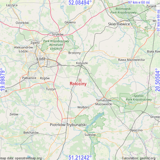
Rokiciny GPS coordinates[2]
51° 39' 2.808" North, 19° 48' 6.876" East
| Map corner | latitude | longitude |
|---|---|---|
| Upper-left | 52.08494°, | 19.09879° |
| Center: | 51.65078°, | 19.80191° |
| Lower-right: | 51.21242°, | 20.50504° |
| Map W x H: | 97×97 km | = 60.3×60.3mi |
| max Lat: | 54.83135° ⇑40.8% North |
| Rokiciny: | 51.65078° |
| min Lat: | ⇓59.2% South 49.21328° |
| min Long | Rokiciny | max Long |
| 14.20249° | 19.80191° | 24.03723° |
| W 55%⇐ | ⇒45% E |
Elevation
Elevation of Rokiciny is 197 m = 646 ft, and this is 5.6 m = 18 ft above average elevation for this country.
| Max E: |
974 m = 3196 ft | 41.1% |
| Rokiciny | 197 m 646 ft | |
| Avg. | 191.4 m = 628 ft | |
Min E: |
-3 m = -10 ft | 58.9% |
See also: Poland elevation on elevation.city.
Geographical zone
Rokiciny is located in North temperate zone (between Tropic of Cancer and the Arctic Circle). Distance of this North polar circle is 1658.1 km =1030.3 mi to North.| Distance of | km | miles | from Rokiciny |
|---|---|---|---|
| North Pole | 4264 | 2649.5 | to North |
| Arctic Circle | 1658.1 | 1030.3 | to North |
| Tropic Cancer | 3137.1 | 1949.3 | to South |
| Equator | 5743 | 3568.5 | to South |


Nearby cities:
15 places around Rokiciny: (largest is in red/bold)
• Andrespol
14 km =8.7 mi,  307°
307°
• Brzeziny
17 km =10.6 mi,  348°
348°
• Brójce
10.7 km =6.6 mi,  278°
278°
• Budziszewice
9.4 km =5.8 mi,  78°
78°
• Będków
7.9 km =4.9 mi,  207°
207°
• Czarnocin
10.6 km =6.6 mi,  231°
231°
• Gałków Duży
10.9 km =6.8 mi,  330°
330°
• Gałków Mały
10.3 km =6.4 mi,  323°
323°
• Koluszki
9.9 km =6.2 mi,  7°
7°
• Moszczenica
17.4 km =10.8 mi,  199°
199°
• Rokiciny-Kolonia
2 km =1.2 mi, 320°
• Ujazd
10.2 km =6.3 mi,  125°
125°
• Wola Rakowa
13.4 km =8.3 mi, 280°
• Wolbórz
16.7 km =10.4 mi,  173°
173°
• Żelechlinek
17.4 km =10.8 mi,  66°
66°
Sources, notices
• [Note1] Compared only with cities in Poland existing in our database
• [Src1] Map data: © OpenStreetMap contributors (CC-BY-SA)
• [Src2] Other city data from geonames.org with taken over terms of usage.
• [Src3] Geographical zone / Annual Mean Temperature by Robert A. Rohde @ Wikipedia
