Mniszków geodata
Mniszków (Łódź Voivodeship) is a seat of a third-order administrative division; located in Poland in Europe/Warsaw (GMT+2) time zone. With population of 525 people, there are 3470 cities with bigger population in this country. Compared to other cities in Poland, 54.4% of cities are located further ↓South; 59% of cities are located further ←West and 67.1% of cities have lower elevation than Mniszków. Note1


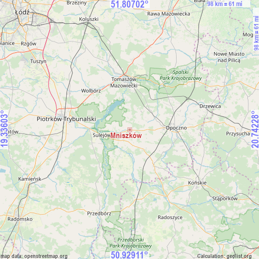
Mniszków GPS coordinates[2]
51° 22' 12.612" North, 20° 2' 20.94" East
| Map corner | latitude | longitude |
|---|---|---|
| Upper-left | 51.80702°, | 19.33603° |
| Center: | 51.37017°, | 20.03915° |
| Lower-right: | 50.92911°, | 20.74228° |
| Map W x H: | 97.6×97.6 km | = 60.6×60.6mi |
| max Lat: | 54.83135° ⇑45.6% North |
| Mniszków: | 51.37017° |
| min Lat: | ⇓54.4% South 49.21328° |
| min Long | Mniszków | max Long |
| 14.20249° | 20.03915° | 24.03723° |
| W 59%⇐ | ⇒41% E |
Elevation
Elevation of Mniszków is 220 m = 722 ft, and this is 28.6 m = 94 ft above average elevation for this country.
| Max E: |
974 m = 3196 ft | 32.9% |
| Mniszków | 220 m 722 ft | |
| Avg. | 191.4 m = 628 ft | |
Min E: |
-3 m = -10 ft | 67.1% |
See also: Poland elevation on elevation.city.
Geographical zone
Mniszków is located in North temperate zone (between Tropic of Cancer and the Arctic Circle). Distance of this North polar circle is 1689.3 km =1049.7 mi to North.| Distance of | km | miles | from Mniszków |
|---|---|---|---|
| North Pole | 4295.2 | 2668.9 | to North |
| Arctic Circle | 1689.3 | 1049.7 | to North |
| Tropic Cancer | 3105.9 | 1929.9 | to South |
| Equator | 5711.8 | 3549.1 | to South |


Nearby cities:
15 places around Mniszków: (largest is in red/bold)
• Aleksandrów
11.5 km =7.1 mi,  197°
197°
• Białaczów
19.6 km =12.2 mi,  114°
114°
• Bukowiec Opoczyński
16.6 km =10.3 mi,  71°
71°
• Inowłódz
21.6 km =13.4 mi,  36°
36°
• Mroczków Gościnny
24.4 km =15.2 mi,  87°
87°
• Opoczno
16.6 km =10.3 mi, 87°
• Paradyż
8.8 km =5.5 mi,  143°
143°
• Piotrków Trybunalski
23.6 km =14.7 mi,  279°
279°
• Ręczno
23.8 km =14.8 mi,  212°
212°
• Sulejów
10.8 km =6.7 mi,  260°
260°
• Sławno
7.5 km =4.7 mi, 70°
• Tomaszów Mazowiecki
18 km =11.2 mi,  353°
353°
• Wola Załężna
19.5 km =12.1 mi,  82°
82°
• Wolbórz
20.6 km =12.8 mi,  315°
315°
• Żarnów
16.7 km =10.4 mi,  145°
145°
Sources, notices
• [Note1] Compared only with cities in Poland existing in our database
• [Src1] Map data: © OpenStreetMap contributors (CC-BY-SA)
• [Src2] Other city data from geonames.org with taken over terms of usage.
• [Src3] Geographical zone / Annual Mean Temperature by Robert A. Rohde @ Wikipedia
