Szklarska Poręba geodata
Szklarska Poręba (Lower Silesia) is a populated place; located in Poland in Europe/Warsaw (GMT+2) time zone. With population of 6,970 people, there are 539 cities with bigger population in this country. Compared to other cities in Poland, 59.6% of cities are located further ↑North; 95.3% of cities are located further →East and 99.2% of cities have lower elevation than Szklarska Poręba. Note1
Administrative division(s):
- Level 1: Lower Silesia
- Level 2: Powiat jeleniogórski
- Level 3: Szklarska Poręba


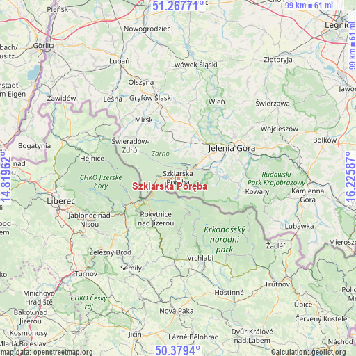
Szklarska Poręba GPS coordinates[2]
50° 49' 32.412" North, 15° 31' 21.864" East
| Map corner | latitude | longitude |
|---|---|---|
| Upper-left | 51.26771°, | 14.81962° |
| Center: | 50.82567°, | 15.52274° |
| Lower-right: | 50.3794°, | 16.22587° |
| Map W x H: | 98.8×98.8 km | = 61.4×61.4mi |
| max Lat: | 54.83135° ⇑59.6% North |
| Szklarska Poręba: | 50.82567° |
| min Lat: | ⇓40.4% South 49.21328° |
| min Long | Szklarska Porę | max Long |
| 14.20249° | 15.52274° | 24.03723° |
| W 4.7%⇐ | ⇒95.3% E |
Elevation
Elevation of Szklarska Poręba is 647 m = 2123 ft, and this is 455.6 m = 1495 ft above average elevation for this country.
| Max E: |
974 m = 3196 ft | 0.8% |
| Szklarska Poręba | 647 m 2123 ft | |
| Avg. | 191.4 m = 628 ft | |
Min E: |
-3 m = -10 ft | 99.2% |
See also: Poland elevation on elevation.city.
Geographical zone
Szklarska Poręba is located in North temperate zone (between Tropic of Cancer and the Arctic Circle). Distance of this North polar circle is 1749.9 km =1087.3 mi to North.| Distance of | km | miles | from Szklarska Poręba |
|---|---|---|---|
| North Pole | 4355.8 | 2706.6 | to North |
| Arctic Circle | 1749.9 | 1087.3 | to North |
| Tropic Cancer | 3045.4 | 1892.3 | to South |
| Equator | 5651.3 | 3511.6 | to South |


Nearby cities:
15 places around Szklarska Poręba: (largest is in red/bold)
• Cieplice Śląskie Zdrój
12.1 km =7.5 mi,  68°
68°
• Jelenia Góra
16.7 km =10.4 mi,  60°
60°
• Jeżów Sudecki
19.7 km =12.2 mi,  51°
51°
• Karpacz
17.3 km =10.7 mi,  108°
108°
• Lubomierz
20.8 km =12.9 mi,  357°
357°
• Mirsk
18.8 km =11.7 mi,  329°
329°
• Mysłakowice
18.1 km =11.2 mi,  84°
84°
• Pasiecznik
15 km =9.3 mi,  13°
13°
• Piechowice
6 km =3.7 mi, 63°
• Pilchowice
18.9 km =11.7 mi,  25°
25°
• Podgórzyn
11.2 km =7 mi,  86°
86°
• Rybnica
12.4 km =7.7 mi, 34°
• Sosnówka
14.1 km =8.8 mi, 93°
• Stara Kamienica
10.6 km =6.6 mi,  19°
19°
• Świeradów-Zdrój
15.7 km =9.8 mi,  306°
306°
Sources, notices
• [Note1] Compared only with cities in Poland existing in our database
• [Src1] Map data: © OpenStreetMap contributors (CC-BY-SA)
• [Src2] Other city data from geonames.org with taken over terms of usage.
• [Src3] Geographical zone / Annual Mean Temperature by Robert A. Rohde @ Wikipedia
