Pilchowice geodata
Pilchowice (Lower Silesia) is a populated place; located in Poland in Europe/Warsaw (GMT+2) time zone. With population of 693 people, there are 3082 cities with bigger population in this country. Compared to other cities in Poland, 55.7% of cities are located further ↑North; 94.6% of cities are located further →East and 72.8% of cities have lower elevation than Pilchowice. Note1


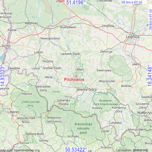
Pilchowice GPS coordinates[2]
50° 58' 44.472" North, 15° 38' 18.06" East
| Map corner | latitude | longitude |
|---|---|---|
| Upper-left | 51.4196°, | 14.93523° |
| Center: | 50.97902°, | 15.63835° |
| Lower-right: | 50.53422°, | 16.34148° |
| Map W x H: | 98.4×98.4 km | = 61.1×61.1mi |
| max Lat: | 54.83135° ⇑55.7% North |
| Pilchowice: | 50.97902° |
| min Lat: | ⇓44.3% South 49.21328° |
| min Long | Pilchowice | max Long |
| 14.20249° | 15.63835° | 24.03723° |
| W 5.4%⇐ | ⇒94.6% E |
Elevation
Elevation of Pilchowice is 239 m = 784 ft, and this is 47.6 m = 156 ft above average elevation for this country.
| Max E: |
974 m = 3196 ft | 27.2% |
| Pilchowice | 239 m 784 ft | |
| Avg. | 191.4 m = 628 ft | |
Min E: |
-3 m = -10 ft | 72.8% |
See also: Poland elevation on elevation.city.
Geographical zone
Pilchowice is located in North temperate zone (between Tropic of Cancer and the Arctic Circle). Distance of this North polar circle is 1732.8 km =1076.7 mi to North.| Distance of | km | miles | from Pilchowice |
|---|---|---|---|
| North Pole | 4338.7 | 2695.9 | to North |
| Arctic Circle | 1732.8 | 1076.7 | to North |
| Tropic Cancer | 3062.4 | 1902.9 | to South |
| Equator | 5668.3 | 3522.1 | to South |


Nearby cities:
15 places around Pilchowice: (largest is in red/bold)
• Cieplice Śląskie Zdrój
13 km =8.1 mi,  165°
165°
• Gryfów Śląski
16.3 km =10.1 mi,  290°
290°
• Jelenia Góra
10.9 km =6.8 mi,  144°
144°
• Jeżów Sudecki
8.8 km =5.5 mi,  123°
123°
• Lubomierz
9.8 km =6.1 mi, 292°
• Lwówek Śląski
15.1 km =9.4 mi,  345°
345°
• Mirsk
17.7 km =11 mi,  266°
266°
• Mysłakowice
18.2 km =11.3 mi,  147°
147°
• Pasiecznik
5.3 km =3.3 mi,  241°
241°
• Piechowice
14.7 km =9.1 mi,  190°
190°
• Podgórzyn
16.6 km =10.3 mi, 169°
• Rybnica
6.9 km =4.3 mi, 189°
• Stara Kamienica
8.4 km =5.2 mi,  213°
213°
• Sędziszowa
17.4 km =10.8 mi,  72°
72°
• Wleń
4.9 km =3 mi,  31°
31°
Sources, notices
• [Note1] Compared only with cities in Poland existing in our database
• [Src1] Map data: © OpenStreetMap contributors (CC-BY-SA)
• [Src2] Other city data from geonames.org with taken over terms of usage.
• [Src3] Geographical zone / Annual Mean Temperature by Robert A. Rohde @ Wikipedia
