Mysłakowice geodata
Mysłakowice (Lower Silesia) is a populated place; located in Poland in Europe/Warsaw (GMT+2) time zone. With population of 5,100 people, there are 679 cities with bigger population in this country. Compared to other cities in Poland, 59.4% of cities are located further ↑North; 93.8% of cities are located further →East and 93.8% of cities have lower elevation than Mysłakowice. Note1
Administrative division(s):
- Level 1: Lower Silesia
- Level 2: Powiat jeleniogórski
- Level 3: Mysłakowice


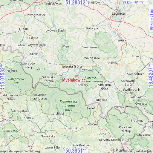
Mysłakowice GPS coordinates[2]
50° 50' 28.428" North, 15° 46' 44.184" East
| Map corner | latitude | longitude |
|---|---|---|
| Upper-left | 51.28312°, | 15.07582° |
| Center: | 50.84123°, | 15.77894° |
| Lower-right: | 50.39511°, | 16.48207° |
| Map W x H: | 98.7×98.7 km | = 61.3×61.3mi |
| max Lat: | 54.83135° ⇑59.4% North |
| Mysłakowice: | 50.84123° |
| min Lat: | ⇓40.6% South 49.21328° |
| min Long | Mysłakowice | max Long |
| 14.20249° | 15.77894° | 24.03723° |
| W 6.2%⇐ | ⇒93.8% E |
Elevation
Elevation of Mysłakowice is 382 m = 1253 ft, and this is 190.6 m = 625 ft above average elevation for this country.
| Max E: |
974 m = 3196 ft | 6.2% |
| Mysłakowice | 382 m 1253 ft | |
| Avg. | 191.4 m = 628 ft | |
Min E: |
-3 m = -10 ft | 93.8% |
See also: Poland elevation on elevation.city.
Geographical zone
Mysłakowice is located in North temperate zone (between Tropic of Cancer and the Arctic Circle). Distance of this North polar circle is 1748.2 km =1086.3 mi to North.| Distance of | km | miles | from Mysłakowice |
|---|---|---|---|
| North Pole | 4354 | 2705.4 | to North |
| Arctic Circle | 1748.2 | 1086.3 | to North |
| Tropic Cancer | 3047.1 | 1893.4 | to South |
| Equator | 5653 | 3512.6 | to South |


Nearby cities:
15 places around Mysłakowice: (largest is in red/bold)
• Cieplice Śląskie Zdrój
7.2 km =4.5 mi,  291°
291°
• Janowice Wielkie
10.8 km =6.7 mi,  69°
69°
• Jelenia Góra
7.4 km =4.6 mi,  331°
331°
• Jeżów Sudecki
10.7 km =6.6 mi,  346°
346°
• Karpacz
7.4 km =4.6 mi,  192°
192°
• Kowary
6.7 km =4.2 mi,  143°
143°
• Marciszów
17 km =10.6 mi,  88°
88°
• Piechowice
12.7 km =7.9 mi,  274°
274°
• Pilchowice
18.2 km =11.3 mi, 327°
• Podgórzyn
6.9 km =4.3 mi,  262°
262°
• Rybnica
13.9 km =8.6 mi,  307°
307°
• Sosnówka
4.7 km =2.9 mi,  236°
236°
• Stara Kamienica
16.7 km =10.4 mi,  299°
299°
• Szklarska Poręba
18.1 km =11.2 mi, 264°
• Wojcieszów
15.9 km =9.9 mi,  39°
39°
Sources, notices
• [Note1] Compared only with cities in Poland existing in our database
• [Src1] Map data: © OpenStreetMap contributors (CC-BY-SA)
• [Src2] Other city data from geonames.org with taken over terms of usage.
• [Src3] Geographical zone / Annual Mean Temperature by Robert A. Rohde @ Wikipedia
