Piechowice geodata
Piechowice (Lower Silesia) is a seat of a third-order administrative division; located in Poland in Europe/Warsaw (GMT+2) time zone. With population of 6,496 people, there are 568 cities with bigger population in this country. Compared to other cities in Poland, 59.1% of cities are located further ↑North; 94.8% of cities are located further →East and 93.6% of cities have lower elevation than Piechowice. Note1
Administrative division(s):
- Level 1: Lower Silesia
- Level 2: Powiat jeleniogórski
- Level 3: Piechowice


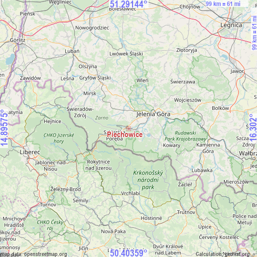
Piechowice GPS coordinates[2]
50° 50' 58.668" North, 15° 35' 55.932" East
| Map corner | latitude | longitude |
|---|---|---|
| Upper-left | 51.29144°, | 14.89575° |
| Center: | 50.84963°, | 15.59887° |
| Lower-right: | 50.40359°, | 16.302° |
| Map W x H: | 98.7×98.7 km | = 61.3×61.3mi |
| max Lat: | 54.83135° ⇑59.1% North |
| Piechowice: | 50.84963° |
| min Lat: | ⇓40.9% South 49.21328° |
| min Long | Piechowice | max Long |
| 14.20249° | 15.59887° | 24.03723° |
| W 5.2%⇐ | ⇒94.8% E |
Elevation
Elevation of Piechowice is 380 m = 1247 ft, and this is 188.6 m = 619 ft above average elevation for this country.
| Max E: |
974 m = 3196 ft | 6.4% |
| Piechowice | 380 m 1247 ft | |
| Avg. | 191.4 m = 628 ft | |
Min E: |
-3 m = -10 ft | 93.6% |
See also: Poland elevation on elevation.city.
Geographical zone
Piechowice is located in North temperate zone (between Tropic of Cancer and the Arctic Circle). Distance of this North polar circle is 1747.2 km =1085.7 mi to North.| Distance of | km | miles | from Piechowice |
|---|---|---|---|
| North Pole | 4353.1 | 2704.9 | to North |
| Arctic Circle | 1747.2 | 1085.7 | to North |
| Tropic Cancer | 3048 | 1893.9 | to South |
| Equator | 5653.9 | 3513.2 | to South |


Nearby cities:
15 places around Piechowice: (largest is in red/bold)
• Cieplice Śląskie Zdrój
6.2 km =3.9 mi,  73°
73°
• Jelenia Góra
10.7 km =6.6 mi,  58°
58°
• Jeżów Sudecki
13.9 km =8.6 mi,  46°
46°
• Karpacz
13.7 km =8.5 mi,  126°
126°
• Kowary
17.8 km =11.1 mi,  110°
110°
• Lubomierz
19.2 km =11.9 mi,  340°
340°
• Mysłakowice
12.7 km =7.9 mi,  94°
94°
• Pasiecznik
12.1 km =7.5 mi,  351°
351°
• Pilchowice
14.7 km =9.1 mi,  10°
10°
• Podgórzyn
6.1 km =3.8 mi, 108°
• Rybnica
7.7 km =4.8 mi, 12°
• Sosnówka
9.4 km =5.8 mi, 111°
• Stara Kamienica
7.6 km =4.7 mi, 346°
• Szklarska Poręba
6 km =3.7 mi,  243°
243°
• Świeradów-Zdrój
19.1 km =11.9 mi,  290°
290°
Sources, notices
• [Note1] Compared only with cities in Poland existing in our database
• [Src1] Map data: © OpenStreetMap contributors (CC-BY-SA)
• [Src2] Other city data from geonames.org with taken over terms of usage.
• [Src3] Geographical zone / Annual Mean Temperature by Robert A. Rohde @ Wikipedia
