Świeradów-Zdrój geodata
Świeradów-Zdrój (Lower Silesia) is a populated place; located in Poland in Europe/Warsaw (GMT+2) time zone. With population of 4,492 people, there are 734 cities with bigger population in this country. Compared to other cities in Poland, 57.4% of cities are located further ↑North; 96.3% of cities are located further →East and 96.9% of cities have lower elevation than Świeradów-Zdrój. Note1
Administrative division(s):
- Level 1: Lower Silesia
- Level 2: Powiat lubański
- Level 3: Świeradów-Zdrój


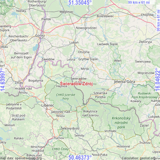
Świeradów-Zdrój GPS coordinates[2]
50° 54' 33.12" North, 15° 20' 35.124" East
| Map corner | latitude | longitude |
|---|---|---|
| Upper-left | 51.35045°, | 14.63997° |
| Center: | 50.9092°, | 15.34309° |
| Lower-right: | 50.46373°, | 16.04622° |
| Map W x H: | 98.6×98.6 km | = 61.3×61.3mi |
| max Lat: | 54.83135° ⇑57.4% North |
| Świeradów-Zdrój: | 50.9092° |
| min Lat: | ⇓42.6% South 49.21328° |
| min Long | Świeradów-Zdr | max Long |
| 14.20249° | 15.34309° | 24.03723° |
| W 3.7%⇐ | ⇒96.3% E |
Elevation
Elevation of Świeradów-Zdrój is 469 m = 1539 ft, and this is 277.6 m = 911 ft above average elevation for this country.
| Max E: |
974 m = 3196 ft | 3.1% |
| Świeradów-Zdrój | 469 m 1539 ft | |
| Avg. | 191.4 m = 628 ft | |
Min E: |
-3 m = -10 ft | 96.9% |
See also: Poland elevation on elevation.city.
Geographical zone
Świeradów-Zdrój is located in North temperate zone (between Tropic of Cancer and the Arctic Circle). Distance of this North polar circle is 1740.6 km =1081.6 mi to North.| Distance of | km | miles | from Świeradów-Zdrój |
|---|---|---|---|
| North Pole | 4346.5 | 2700.8 | to North |
| Arctic Circle | 1740.6 | 1081.6 | to North |
| Tropic Cancer | 3054.7 | 1898.1 | to South |
| Equator | 5660.6 | 3517.3 | to South |


Nearby cities:
15 places around Świeradów-Zdrój: (largest is in red/bold)
• Cieplice Śląskie Zdrój
24.4 km =15.2 mi,  101°
101°
• Gryfów Śląski
14.6 km =9.1 mi,  21°
21°
• Leśna
13.9 km =8.6 mi,  336°
336°
• Lubań
23.8 km =14.8 mi,  350°
350°
• Lubomierz
16.4 km =10.2 mi,  45°
45°
• Mirsk
7.4 km =4.6 mi, 23°
• Olszyna
17.7 km =11 mi,  6°
6°
• Pasiecznik
16.9 km =10.5 mi,  71°
71°
• Piechowice
19.1 km =11.9 mi,  110°
110°
• Pilchowice
22.1 km =13.7 mi, 69°
• Platerówka
20.6 km =12.8 mi,  324°
324°
• Rybnica
19.6 km =12.2 mi,  87°
87°
• Stara Kamienica
16.1 km =10 mi, 87°
• Szklarska Poręba
15.7 km =9.8 mi,  126°
126°
• Zawidów
23.5 km =14.6 mi,  303°
303°
In other languages:
- In German: Swieradow-Zdroj/Bad Flinsberg
- In Russian: Сверадув-Здруй
- In Chinese: 希維拉杜夫-茲德魯伊
Sources, notices
• [Note1] Compared only with cities in Poland existing in our database
• [Src1] Map data: © OpenStreetMap contributors (CC-BY-SA)
• [Src2] Other city data from geonames.org with taken over terms of usage.
• [Src3] Geographical zone / Annual Mean Temperature by Robert A. Rohde @ Wikipedia
