Czarnogłowy geodata
Czarnogłowy (West Pomerania) is a populated place; located in Poland in Europe/Warsaw (GMT+2) time zone. With population of 977 people, there are 2542 cities with bigger population in this country. Compared to other cities in Poland, 92% of cities are located further ↓South; 98.5% of cities are located further →East and 96.1% of cities have higher elevation than Czarnogłowy. Note1
Administrative division(s):
- Level 1: West Pomerania
- Level 2: Powiat goleniowski
- Level 3: Przybiernów


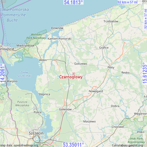
Czarnogłowy GPS coordinates[2]
53° 46' 3.936" North, 14° 54' 33.192" East
| Map corner | latitude | longitude |
|---|---|---|
| Upper-left | 54.1813°, | 14.2061° |
| Center: | 53.76776°, | 14.90922° |
| Lower-right: | 53.35011°, | 15.61235° |
| Map W x H: | 92.4×92.4 km | = 57.4×57.4mi |
| max Lat: | 54.83135° ⇑8% North |
| Czarnogłowy: | 53.76776° |
| min Lat: | ⇓92% South 49.21328° |
| min Long | Czarnogłowy | max Long |
| 14.20249° | 14.90922° | 24.03723° |
| W 1.5%⇐ | ⇒98.5% E |
Elevation
Elevation of Czarnogłowy is 31 m = 102 ft, and this is 160.4 m = 526 ft below average elevation for this country.
| Max E: |
974 m = 3196 ft | 96.1% |
| Avg. | 191.4 m = 628 ft | |
| Czarnogłowy | 31 m = 102 ft | |
Min E: |
-3 m = -10 ft | 3.9% |
See also: Poland elevation on elevation.city.
Geographical zone
Czarnogłowy is located in North temperate zone (between Tropic of Cancer and the Arctic Circle). Distance of this North polar circle is 1422.8 km =884.1 mi to North.| Distance of | km | miles | from Czarnogłowy |
|---|---|---|---|
| North Pole | 4028.6 | 2503.3 | to North |
| Arctic Circle | 1422.8 | 884.1 | to North |
| Tropic Cancer | 3372.5 | 2095.6 | to South |
| Equator | 5978.4 | 3714.8 | to South |


Nearby cities:
15 places around Czarnogłowy: (largest is in red/bold)
• Cerkwica
29.7 km =18.5 mi,  26°
26°
• Golczewo
7.8 km =4.8 mi,  35°
35°
• Goleniów
23.3 km =14.5 mi,  193°
193°
• Gostyń
29.1 km =18.1 mi,  4°
4°
• Gryfice
25.3 km =15.7 mi,  49°
49°
• Kamień Pomorski
24 km =14.9 mi,  338°
338°
• Międzywodzie
29.8 km =18.5 mi,  332°
332°
• Mosty
24.6 km =15.3 mi,  172°
172°
• Nowogard
17.1 km =10.6 mi,  127°
127°
• Osina
19.4 km =12.1 mi,  159°
159°
• Przybiernów
8.2 km =5.1 mi,  262°
262°
• Płoty
23.8 km =14.8 mi,  80°
80°
• Stepnica
22.7 km =14.1 mi,  235°
235°
• Wolin
21 km =13 mi,  293°
293°
• Świerzno
22.2 km =13.8 mi,  9°
9°
Sources, notices
• [Note1] Compared only with cities in Poland existing in our database
• [Src1] Map data: © OpenStreetMap contributors (CC-BY-SA)
• [Src2] Other city data from geonames.org with taken over terms of usage.
• [Src3] Geographical zone / Annual Mean Temperature by Robert A. Rohde @ Wikipedia
