Wola geodata
Wola (Silesia) is a populated place; located in Poland in Europe/Warsaw (GMT+2) time zone. With population of 8,508 people, there are 494 cities with bigger population in this country. Compared to other cities in Poland, 81.5% of cities are located further ↑North; 57.7% of cities are located further →East and 72.8% of cities have lower elevation than Wola. Note1


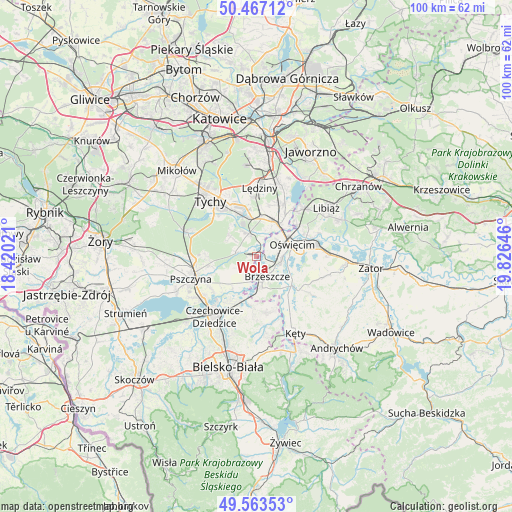
Wola GPS coordinates[2]
50° 1' 2.82" North, 19° 7' 23.988" East
| Map corner | latitude | longitude |
|---|---|---|
| Upper-left | 50.46712°, | 18.42021° |
| Center: | 50.01745°, | 19.12333° |
| Lower-right: | 49.56353°, | 19.82646° |
| Map W x H: | 100.5×100.5 km | = 62.4×62.4mi |
| max Lat: | 54.83135° ⇑81.5% North |
| Wola: | 50.01745° |
| min Lat: | ⇓18.5% South 49.21328° |
| min Long | Wola | max Long |
| 14.20249° | 19.12333° | 24.03723° |
| W 42.3%⇐ | ⇒57.7% E |
Elevation
Elevation of Wola is 239 m = 784 ft, and this is 47.6 m = 156 ft above average elevation for this country.
| Max E: |
974 m = 3196 ft | 27.2% |
| Wola | 239 m 784 ft | |
| Avg. | 191.4 m = 628 ft | |
Min E: |
-3 m = -10 ft | 72.8% |
See also: Poland elevation on elevation.city.
Geographical zone
Wola is located in North temperate zone (between Tropic of Cancer and the Arctic Circle). Distance of this North polar circle is 1839.8 km =1143.2 mi to North.| Distance of | km | miles | from Wola |
|---|---|---|---|
| North Pole | 4445.6 | 2762.4 | to North |
| Arctic Circle | 1839.8 | 1143.2 | to North |
| Tropic Cancer | 2955.5 | 1836.5 | to South |
| Equator | 5561.4 | 3455.7 | to South |


Nearby cities:
15 places around Wola: (largest is in red/bold)
• Babice
6.9 km =4.3 mi,  52°
52°
• Bojszowy
4.8 km =3 mi,  340°
340°
• Bojszowy Nowe
6.5 km =4 mi,  306°
306°
• Brzeszcze
4.4 km =2.7 mi,  152°
152°
• Brzezinka
5.5 km =3.4 mi,  59°
59°
• Frydek
4.3 km =2.7 mi,  236°
236°
• Gilowice
3.2 km =2 mi,  217°
217°
• Góra
4.4 km =2.7 mi,  197°
197°
• Harmęże
2.8 km =1.7 mi,  81°
81°
• Miedźna
6.6 km =4.1 mi,  233°
233°
• Międzyrzecze
4.2 km =2.6 mi,  280°
280°
• Oświęcim
6.5 km =4 mi,  73°
73°
• Przecieszyn
5.5 km =3.4 mi,  142°
142°
• Rajsko
5 km =3.1 mi,  97°
97°
• Skidziń
6.9 km =4.3 mi,  128°
128°
Sources, notices
• [Note1] Compared only with cities in Poland existing in our database
• [Src1] Map data: © OpenStreetMap contributors (CC-BY-SA)
• [Src2] Other city data from geonames.org with taken over terms of usage.
• [Src3] Geographical zone / Annual Mean Temperature by Robert A. Rohde @ Wikipedia
