Gilowice geodata
Gilowice (Silesia) is a populated place; located in Poland in Europe/Warsaw (GMT+2) time zone. With population of 1,214 people, there are 2153 cities with bigger population in this country. Compared to other cities in Poland, 82.7% of cities are located further ↑North; 58.4% of cities are located further →East and 74.2% of cities have lower elevation than Gilowice. Note1


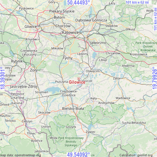
Gilowice GPS coordinates[2]
49° 59' 42.18" North, 19° 5' 46.068" East
| Map corner | latitude | longitude |
|---|---|---|
| Upper-left | 50.44493°, | 18.39301° |
| Center: | 49.99505°, | 19.09613° |
| Lower-right: | 49.54092°, | 19.79926° |
| Map W x H: | 100.5×100.5 km | = 62.4×62.4mi |
| max Lat: | 54.83135° ⇑82.7% North |
| Gilowice: | 49.99505° |
| min Lat: | ⇓17.3% South 49.21328° |
| min Long | Gilowice | max Long |
| 14.20249° | 19.09613° | 24.03723° |
| W 41.6%⇐ | ⇒58.4% E |
Elevation
Elevation of Gilowice is 243 m = 797 ft, and this is 51.6 m = 169 ft above average elevation for this country.
| Max E: |
974 m = 3196 ft | 25.8% |
| Gilowice | 243 m 797 ft | |
| Avg. | 191.4 m = 628 ft | |
Min E: |
-3 m = -10 ft | 74.2% |
See also: Poland elevation on elevation.city.
Geographical zone
Gilowice is located in North temperate zone (between Tropic of Cancer and the Arctic Circle). Distance of this North polar circle is 1842.2 km =1144.7 mi to North.| Distance of | km | miles | from Gilowice |
|---|---|---|---|
| North Pole | 4448.1 | 2763.9 | to North |
| Arctic Circle | 1842.2 | 1144.7 | to North |
| Tropic Cancer | 2953 | 1834.9 | to South |
| Equator | 5558.9 | 3454.1 | to South |


Nearby cities:
15 places around Gilowice: (largest is in red/bold)
• Bestwinka
7.2 km =4.5 mi,  196°
196°
• Bojszowy
7 km =4.3 mi,  3°
3°
• Bojszowy Nowe
7.2 km =4.5 mi,  332°
332°
• Brzeszcze
4.2 km =2.6 mi,  110°
110°
• Frydek
1.7 km =1.1 mi,  274°
274°
• Góra
1.8 km =1.1 mi,  160°
160°
• Harmęże
5.5 km =3.4 mi,  58°
58°
• Jankowice
7.7 km =4.8 mi, 274°
• Kaniów
6.6 km =4.1 mi,  209°
209°
• Miedźna
3.7 km =2.3 mi,  247°
247°
• Międzyrzecze
4 km =2.5 mi, 325°
• Przecieszyn
5.6 km =3.5 mi, 109°
• Rajsko
7.2 km =4.5 mi,  74°
74°
• Skidziń
7.5 km =4.7 mi,  103°
103°
• Wola
3.2 km =2 mi,  37°
37°
Sources, notices
• [Note1] Compared only with cities in Poland existing in our database
• [Src1] Map data: © OpenStreetMap contributors (CC-BY-SA)
• [Src2] Other city data from geonames.org with taken over terms of usage.
• [Src3] Geographical zone / Annual Mean Temperature by Robert A. Rohde @ Wikipedia
