Bojszowy geodata
Bojszowy (Silesia) is a seat of a third-order administrative division; located in Poland in Europe/Warsaw (GMT+2) time zone. With population of 3,219 people, there are 986 cities with bigger population in this country. Compared to other cities in Poland, 79.8% of cities are located further ↑North; 58.3% of cities are located further →East and 70.9% of cities have lower elevation than Bojszowy. Note1


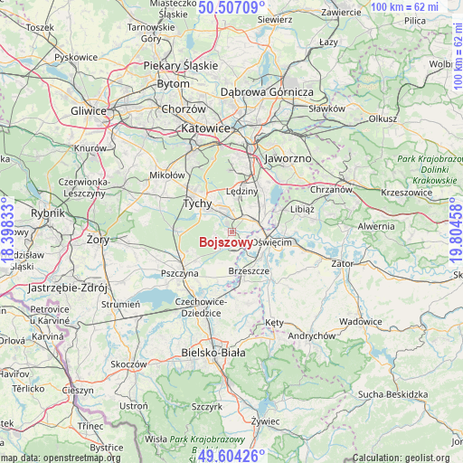
Bojszowy GPS coordinates[2]
50° 3' 28.08" North, 19° 6' 5.22" East
| Map corner | latitude | longitude |
|---|---|---|
| Upper-left | 50.50709°, | 18.39833° |
| Center: | 50.0578°, | 19.10145° |
| Lower-right: | 49.60426°, | 19.80458° |
| Map W x H: | 100.4×100.4 km | = 62.4×62.4mi |
| max Lat: | 54.83135° ⇑79.8% North |
| Bojszowy: | 50.0578° |
| min Lat: | ⇓20.2% South 49.21328° |
| min Long | Bojszowy | max Long |
| 14.20249° | 19.10145° | 24.03723° |
| W 41.7%⇐ | ⇒58.3% E |
Elevation
Elevation of Bojszowy is 232 m = 761 ft, and this is 40.6 m = 133 ft above average elevation for this country.
| Max E: |
974 m = 3196 ft | 29.1% |
| Bojszowy | 232 m 761 ft | |
| Avg. | 191.4 m = 628 ft | |
Min E: |
-3 m = -10 ft | 70.9% |
See also: Poland elevation on elevation.city.
Geographical zone
Bojszowy is located in North temperate zone (between Tropic of Cancer and the Arctic Circle). Distance of this North polar circle is 1835.3 km =1140.4 mi to North.| Distance of | km | miles | from Bojszowy |
|---|---|---|---|
| North Pole | 4441.2 | 2759.6 | to North |
| Arctic Circle | 1835.3 | 1140.4 | to North |
| Tropic Cancer | 2960 | 1839.3 | to South |
| Equator | 5565.9 | 3458.5 | to South |


Nearby cities:
15 places around Bojszowy: (largest is in red/bold)
• Babice
7 km =4.3 mi,  91°
91°
• Bieruń
3.6 km =2.2 mi,  350°
350°
• Bojszowy Nowe
3.7 km =2.3 mi,  261°
261°
• Brzeszcze
9.2 km =5.7 mi,  156°
156°
• Brzezinka
6.6 km =4.1 mi,  105°
105°
• Chełm Śląski
8.7 km =5.4 mi,  50°
50°
• Cielmice
6.8 km =4.2 mi,  299°
299°
• Frydek
7.1 km =4.4 mi,  196°
196°
• Gilowice
7 km =4.3 mi,  183°
183°
• Góra
8.7 km =5.4 mi, 178°
• Harmęże
6 km =3.7 mi,  133°
133°
• Międzyrzecze
4.5 km =2.8 mi,  215°
215°
• Oświęcim
8.2 km =5.1 mi, 108°
• Rajsko
8.3 km =5.2 mi, 127°
• Wola
4.8 km =3 mi, 160°
Sources, notices
• [Note1] Compared only with cities in Poland existing in our database
• [Src1] Map data: © OpenStreetMap contributors (CC-BY-SA)
• [Src2] Other city data from geonames.org with taken over terms of usage.
• [Src3] Geographical zone / Annual Mean Temperature by Robert A. Rohde @ Wikipedia
