Krzeszowice geodata
Krzeszowice (Lesser Poland) is a seat of a third-order administrative division; located in Poland in Europe/Warsaw (GMT+2) time zone. With population of 9,978 people, there are 445 cities with bigger population in this country. Compared to other cities in Poland, 76.4% of cities are located further ↑North; 51.5% of cities are located further ←West and 81.2% of cities have lower elevation than Krzeszowice. Note1


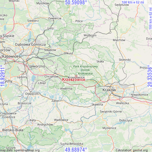
Krzeszowice GPS coordinates[2]
50° 8' 32.928" North, 19° 37' 56.028" East
| Map corner | latitude | longitude |
|---|---|---|
| Upper-left | 50.59098°, | 18.92911° |
| Center: | 50.14248°, | 19.63223° |
| Lower-right: | 49.68974°, | 20.33536° |
| Map W x H: | 100.2×100.2 km | = 62.3×62.3mi |
| max Lat: | 54.83135° ⇑76.4% North |
| Krzeszowice: | 50.14248° |
| min Lat: | ⇓23.6% South 49.21328° |
| min Long | Krzeszowice | max Long |
| 14.20249° | 19.63223° | 24.03723° |
| W 51.5%⇐ | ⇒48.5% E |
Elevation
Elevation of Krzeszowice is 271 m = 889 ft, and this is 79.6 m = 261 ft above average elevation for this country.
| Max E: |
974 m = 3196 ft | 18.8% |
| Krzeszowice | 271 m 889 ft | |
| Avg. | 191.4 m = 628 ft | |
Min E: |
-3 m = -10 ft | 81.2% |
See also: Poland elevation on elevation.city.
Geographical zone
Krzeszowice is located in North temperate zone (between Tropic of Cancer and the Arctic Circle). Distance of this North polar circle is 1825.9 km =1134.6 mi to North.| Distance of | km | miles | from Krzeszowice |
|---|---|---|---|
| North Pole | 4431.7 | 2753.7 | to North |
| Arctic Circle | 1825.9 | 1134.6 | to North |
| Tropic Cancer | 2969.4 | 1845.1 | to South |
| Equator | 5575.3 | 3464.3 | to South |


Nearby cities:
15 places around Krzeszowice: (largest is in red/bold)
• Brzezinka
7.7 km =4.8 mi,  95°
95°
• Brzoskwinia
7.8 km =4.8 mi,  133°
133°
• Filipowice
5 km =3.1 mi,  287°
287°
• Gorenice
7.3 km =4.5 mi,  353°
353°
• Grojec
7.9 km =4.9 mi,  222°
222°
• Miękinia
2.2 km =1.4 mi,  310°
310°
• Nielepice
6.2 km =3.9 mi, 127°
• Nowa Góra
4.5 km =2.8 mi,  319°
319°
• Ostrężnica
7.1 km =4.4 mi, 321°
• Racławice
6.5 km =4 mi,  29°
29°
• Rudawa
6.2 km =3.9 mi,  112°
112°
• Rudno
6.2 km =3.9 mi, 219°
• Tenczynek
2.9 km =1.8 mi,  208°
208°
• Wola Filipowska
3.8 km =2.4 mi,  256°
256°
• Zalas
7 km =4.3 mi,  186°
186°
Sources, notices
• [Note1] Compared only with cities in Poland existing in our database
• [Src1] Map data: © OpenStreetMap contributors (CC-BY-SA)
• [Src2] Other city data from geonames.org with taken over terms of usage.
• [Src3] Geographical zone / Annual Mean Temperature by Robert A. Rohde @ Wikipedia
