Sąspów geodata
Sąspów (Lesser Poland) is a populated place; located in Poland in Europe/Warsaw (GMT+2) time zone. With population of 1,358 people, there are 2016 cities with bigger population in this country. Compared to other cities in Poland, 73.8% of cities are located further ↑North; 54.2% of cities are located further ←West and 96.5% of cities have lower elevation than Sąspów. Note1
Administrative division(s):
- Level 1: Lesser Poland
- Level 2: Powiat krakowski
- Level 3: Jerzmanowice-Przeginia


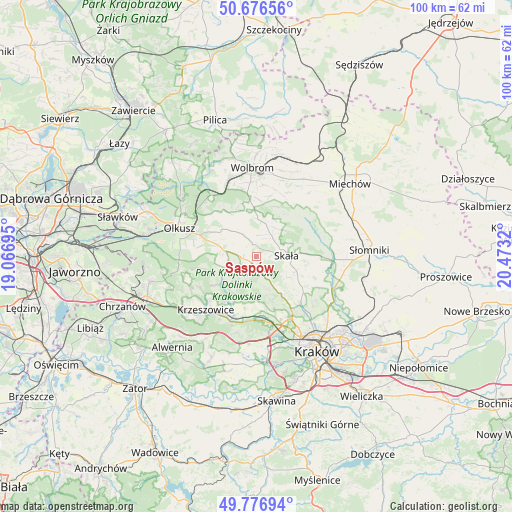
Sąspów GPS coordinates[2]
50° 13' 43.932" North, 19° 46' 12.252" East
| Map corner | latitude | longitude |
|---|---|---|
| Upper-left | 50.67656°, | 19.06695° |
| Center: | 50.22887°, | 19.77007° |
| Lower-right: | 49.77694°, | 20.4732° |
| Map W x H: | 100×100 km | = 62.1×62.1mi |
| max Lat: | 54.83135° ⇑73.8% North |
| Sąspów: | 50.22887° |
| min Lat: | ⇓26.2% South 49.21328° |
| min Long | Sąspów | max Long |
| 14.20249° | 19.77007° | 24.03723° |
| W 54.2%⇐ | ⇒45.8% E |
Elevation
Elevation of Sąspów is 453 m = 1486 ft, and this is 261.6 m = 858 ft above average elevation for this country.
| Max E: |
974 m = 3196 ft | 3.5% |
| Sąspów | 453 m 1486 ft | |
| Avg. | 191.4 m = 628 ft | |
Min E: |
-3 m = -10 ft | 96.5% |
See also: Poland elevation on elevation.city.
Geographical zone
Sąspów is located in North temperate zone (between Tropic of Cancer and the Arctic Circle). Distance of this North polar circle is 1816.2 km =1128.5 mi to North.| Distance of | km | miles | from Sąspów |
|---|---|---|---|
| North Pole | 4422.1 | 2747.8 | to North |
| Arctic Circle | 1816.2 | 1128.5 | to North |
| Tropic Cancer | 2979 | 1851.1 | to South |
| Equator | 5584.9 | 3470.3 | to South |


Nearby cities:
15 places around Sąspów: (largest is in red/bold)
• Bolechowice
9.1 km =5.7 mi,  169°
169°
• Brzezinka
10.5 km =6.5 mi,  192°
192°
• Bębło
5.5 km =3.4 mi, 167°
• Gorenice
10.9 km =6.8 mi,  257°
257°
• Jerzmanowice
2.5 km =1.6 mi,  222°
222°
• Karniowice
8.7 km =5.4 mi,  175°
175°
• Kobylany
8.8 km =5.5 mi, 184°
• Przeginia
5.9 km =3.7 mi,  280°
280°
• Racławice
7.7 km =4.8 mi,  239°
239°
• Skała
5.9 km =3.7 mi,  88°
88°
• Sułoszowa
5.1 km =3.2 mi,  328°
328°
• Trzyciąż
9 km =5.6 mi,  358°
358°
• Wielka Wieś
9.6 km =6 mi,  146°
146°
• Więckowice
10.2 km =6.3 mi, 182°
• Zelków
7.9 km =4.9 mi, 166°
Sources, notices
• [Note1] Compared only with cities in Poland existing in our database
• [Src1] Map data: © OpenStreetMap contributors (CC-BY-SA)
• [Src2] Other city data from geonames.org with taken over terms of usage.
• [Src3] Geographical zone / Annual Mean Temperature by Robert A. Rohde @ Wikipedia
