Tenczynek geodata
Tenczynek (Lesser Poland) is a populated place; located in Poland in Europe/Warsaw (GMT+2) time zone. With population of 3,436 people, there are 927 cities with bigger population in this country. Compared to other cities in Poland, 77.3% of cities are located further ↑North; 51% of cities are located further ←West and 79.4% of cities have lower elevation than Tenczynek. Note1


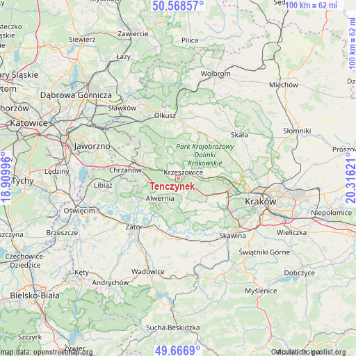
Tenczynek GPS coordinates[2]
50° 7' 11.496" North, 19° 36' 47.088" East
| Map corner | latitude | longitude |
|---|---|---|
| Upper-left | 50.56857°, | 18.90996° |
| Center: | 50.11986°, | 19.61308° |
| Lower-right: | 49.6669°, | 20.31621° |
| Map W x H: | 100.3×100.3 km | = 62.3×62.3mi |
| max Lat: | 54.83135° ⇑77.3% North |
| Tenczynek: | 50.11986° |
| min Lat: | ⇓22.7% South 49.21328° |
| min Long | Tenczynek | max Long |
| 14.20249° | 19.61308° | 24.03723° |
| W 51%⇐ | ⇒49% E |
Elevation
Elevation of Tenczynek is 263 m = 863 ft, and this is 71.6 m = 235 ft above average elevation for this country.
| Max E: |
974 m = 3196 ft | 20.6% |
| Tenczynek | 263 m 863 ft | |
| Avg. | 191.4 m = 628 ft | |
Min E: |
-3 m = -10 ft | 79.4% |
See also: Poland elevation on elevation.city.
Geographical zone
Tenczynek is located in North temperate zone (between Tropic of Cancer and the Arctic Circle). Distance of this North polar circle is 1828.4 km =1136.1 mi to North.| Distance of | km | miles | from Tenczynek |
|---|---|---|---|
| North Pole | 4434.3 | 2755.3 | to North |
| Arctic Circle | 1828.4 | 1136.1 | to North |
| Tropic Cancer | 2966.9 | 1843.5 | to South |
| Equator | 5572.8 | 3462.8 | to South |


Nearby cities:
15 places around Tenczynek: (largest is in red/bold)
• Alwernia
8.4 km =5.2 mi,  218°
218°
• Brzoskwinia
7.6 km =4.7 mi,  111°
111°
• Filipowice
5.2 km =3.2 mi,  319°
319°
• Grojec
5.2 km =3.2 mi,  230°
230°
• Krzeszowice
2.9 km =1.8 mi,  28°
28°
• Miękinia
4 km =2.5 mi,  355°
355°
• Nielepice
6.4 km =4 mi,  101°
101°
• Nowa Góra
6.1 km =3.8 mi,  345°
345°
• Psary
8.3 km =5.2 mi,  314°
314°
• Regulice
7.3 km =4.5 mi,  236°
236°
• Rudawa
7.1 km =4.4 mi,  88°
88°
• Rudno
3.5 km =2.2 mi, 228°
• Sanka
6.2 km =3.9 mi,  157°
157°
• Wola Filipowska
2.8 km =1.7 mi,  304°
304°
• Zalas
4.4 km =2.7 mi,  172°
172°
Sources, notices
• [Note1] Compared only with cities in Poland existing in our database
• [Src1] Map data: © OpenStreetMap contributors (CC-BY-SA)
• [Src2] Other city data from geonames.org with taken over terms of usage.
• [Src3] Geographical zone / Annual Mean Temperature by Robert A. Rohde @ Wikipedia
