Pietrzykowice geodata
Pietrzykowice (Lower Silesia) is a populated place; located in Poland in Europe/Warsaw (GMT+2) time zone. With population of 512 people, there are 3510 cities with bigger population in this country. Compared to other cities in Poland, 53.8% of cities are located further ↑North; 86.3% of cities are located further →East and 65% of cities have higher elevation than Pietrzykowice. Note1
Administrative division(s):
- Level 1: Lower Silesia
- Level 2: Powiat wrocławski
- Level 3: Kąty Wrocławskie


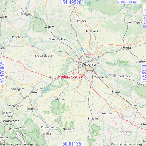
Pietrzykowice GPS coordinates[2]
51° 3' 19.512" North, 16° 52' 47.928" East
| Map corner | latitude | longitude |
|---|---|---|
| Upper-left | 51.49528°, | 16.17686° |
| Center: | 51.05542°, | 16.87998° |
| Lower-right: | 50.61135°, | 17.58311° |
| Map W x H: | 98.3×98.3 km | = 61.1×61.1mi |
| max Lat: | 54.83135° ⇑53.8% North |
| Pietrzykowice: | 51.05542° |
| min Lat: | ⇓46.2% South 49.21328° |
| min Long | Pietrzykowice | max Long |
| 14.20249° | 16.87998° | 24.03723° |
| W 13.7%⇐ | ⇒86.3% E |
Elevation
Elevation of Pietrzykowice is 133 m = 436 ft, and this is 58.4 m = 192 ft below average elevation for this country.
| Max E: |
974 m = 3196 ft | 65% |
| Avg. | 191.4 m = 628 ft | |
| Pietrzykowice | 133 m = 436 ft | |
Min E: |
-3 m = -10 ft | 35% |
See also: Poland elevation on elevation.city.
Geographical zone
Pietrzykowice is located in North temperate zone (between Tropic of Cancer and the Arctic Circle). Distance of this North polar circle is 1724.3 km =1071.4 mi to North.| Distance of | km | miles | from Pietrzykowice |
|---|---|---|---|
| North Pole | 4330.2 | 2690.7 | to North |
| Arctic Circle | 1724.3 | 1071.4 | to North |
| Tropic Cancer | 3070.9 | 1908.2 | to South |
| Equator | 5676.8 | 3527.4 | to South |


Nearby cities:
15 places around Pietrzykowice: (largest is in red/bold)
• Bielany Wrocławskie
6.5 km =4 mi,  109°
109°
• Domasław
7.2 km =4.5 mi,  132°
132°
• Gniechowice
8.2 km =5.1 mi,  203°
203°
• Grabiszyn
8.1 km =5 mi,  58°
58°
• Grabiszynek
8.2 km =5.1 mi, 64°
• Jarnołtów-Jerzmanowo
7.4 km =4.6 mi,  352°
352°
• Krzyki
8.2 km =5.1 mi,  77°
77°
• Kąty Wrocławskie
8.3 km =5.2 mi,  250°
250°
• Małkowice
4.7 km =2.9 mi,  301°
301°
• Nowe Żerniki-Kolonie Żernickie
9.4 km =5.8 mi,  18°
18°
• Rejon ulicy Saperów
9.1 km =5.7 mi,  67°
67°
• Smolec
2 km =1.2 mi,  4°
4°
• Strachowice-Osiniec
5.7 km =3.5 mi,  7°
7°
• Tyniec Mały
4.9 km =3 mi,  145°
145°
• Złotniki
9.2 km =5.7 mi, 4°
Sources, notices
• [Note1] Compared only with cities in Poland existing in our database
• [Src1] Map data: © OpenStreetMap contributors (CC-BY-SA)
• [Src2] Other city data from geonames.org with taken over terms of usage.
• [Src3] Geographical zone / Annual Mean Temperature by Robert A. Rohde @ Wikipedia
