Kąty Wrocławskie geodata
Kąty Wrocławskie (Lower Silesia) is a seat of a third-order administrative division; located in Poland in Europe/Warsaw (GMT+2) time zone. With population of 5,418 people, there are 647 cities with bigger population in this country. Compared to other cities in Poland, 54.5% of cities are located further ↑North; 87.5% of cities are located further →East and 64.1% of cities have higher elevation than Kąty Wrocławskie. Note1
Administrative division(s):
- Level 1: Lower Silesia
- Level 2: Powiat wrocławski
- Level 3: Kąty Wrocławskie


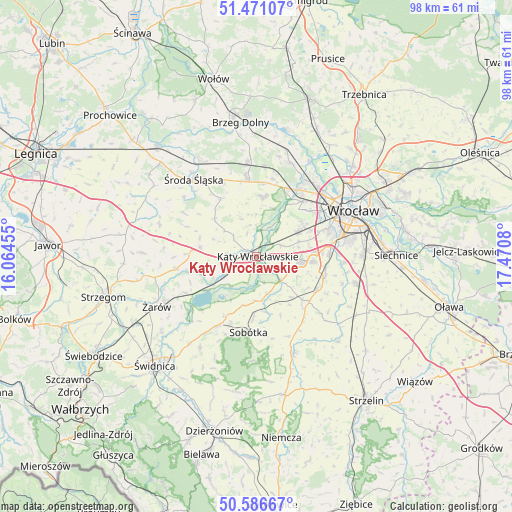
Kąty Wrocławskie GPS coordinates[2]
51° 1' 51.528" North, 16° 46' 3.612" East
| Map corner | latitude | longitude |
|---|---|---|
| Upper-left | 51.47107°, | 16.06455° |
| Center: | 51.03098°, | 16.76767° |
| Lower-right: | 50.58667°, | 17.4708° |
| Map W x H: | 98.3×98.3 km | = 61.1×61.1mi |
| max Lat: | 54.83135° ⇑54.5% North |
| Kąty Wrocławskie: | 51.03098° |
| min Lat: | ⇓45.5% South 49.21328° |
| min Long | Kąty Wrocławs | max Long |
| 14.20249° | 16.76767° | 24.03723° |
| W 12.5%⇐ | ⇒87.5% E |
Elevation
Elevation of Kąty Wrocławskie is 136 m = 446 ft, and this is 55.4 m = 182 ft below average elevation for this country.
| Max E: |
974 m = 3196 ft | 64.1% |
| Avg. | 191.4 m = 628 ft | |
| Kąty Wrocławskie | 136 m = 446 ft | |
Min E: |
-3 m = -10 ft | 35.9% |
See also: Poland elevation on elevation.city.
Geographical zone
Kąty Wrocławskie is located in North temperate zone (between Tropic of Cancer and the Arctic Circle). Distance of this North polar circle is 1727.1 km =1073.2 mi to North.| Distance of | km | miles | from Kąty Wrocławskie |
|---|---|---|---|
| North Pole | 4332.9 | 2692.3 | to North |
| Arctic Circle | 1727.1 | 1073.2 | to North |
| Tropic Cancer | 3068.2 | 1906.5 | to South |
| Equator | 5674.1 | 3525.7 | to South |


Nearby cities:
15 places around Kąty Wrocławskie: (largest is in red/bold)
• Bielany Wrocławskie
14 km =8.7 mi,  87°
87°
• Domasław
13.4 km =8.3 mi,  99°
99°
• Gniechowice
6.6 km =4.1 mi,  135°
135°
• Jarnołtów-Jerzmanowo
12.2 km =7.6 mi,  34°
34°
• Kobierzyce
13.5 km =8.4 mi,  119°
119°
• Kostomłoty
11.1 km =6.9 mi,  278°
278°
• Leśnica-Ratyń-Pustki
13.6 km =8.5 mi,  24°
24°
• Lutynia
11.7 km =7.3 mi,  5°
5°
• Małkowice
6.4 km =4 mi,  37°
37°
• Pietrzykowice
8.3 km =5.2 mi,  70°
70°
• Smolec
9.3 km =5.8 mi,  59°
59°
• Sobótka
14.7 km =9.1 mi,  186°
186°
• Strachowice-Osiniec
12 km =7.5 mi,  45°
45°
• Tyniec Mały
10.7 km =6.6 mi, 96°
• Złotniki
14.6 km =9.1 mi, 35°
Sources, notices
• [Note1] Compared only with cities in Poland existing in our database
• [Src1] Map data: © OpenStreetMap contributors (CC-BY-SA)
• [Src2] Other city data from geonames.org with taken over terms of usage.
• [Src3] Geographical zone / Annual Mean Temperature by Robert A. Rohde @ Wikipedia
