Golub-Dobrzyń geodata
Golub-Dobrzyń (Kujawsko-Pomorskie) is a seat of a third-order administrative division; located in Poland in Europe/Warsaw (GMT+1) time zone. With population of 12,937 people, there are 372 cities with bigger population in this country. Compared to other cities in Poland, 85.1% of cities are located further ↓South; 59.1% of cities are located further →East and 92.5% of cities have higher elevation than Golub-Dobrzyń. Note1
Administrative division(s):
- Level 1: Kujawsko-Pomorskie
- Level 2: Powiat golubsko-dobrzyński
- Level 3: Golub-Dobrzyń


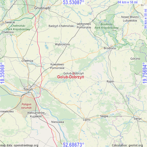
Golub-Dobrzyń GPS coordinates[2]
53° 6' 39.132" North, 19° 3' 13.716" East
| Map corner | latitude | longitude |
|---|---|---|
| Upper-left | 53.53087°, | 18.35069° |
| Center: | 53.11087°, | 19.05381° |
| Lower-right: | 52.68673°, | 19.75694° |
| Map W x H: | 93.9×93.9 km | = 58.3×58.3mi |
| max Lat: | 54.83135° ⇑14.9% North |
| Golub-Dobrzyń: | 53.11087° |
| min Lat: | ⇓85.1% South 49.21328° |
| min Long | Golub-Dobrzyń | max Long |
| 14.20249° | 19.05381° | 24.03723° |
| W 40.9%⇐ | ⇒59.1% E |
Elevation
Elevation of Golub-Dobrzyń is 62 m = 203 ft, and this is 129.4 m = 425 ft below average elevation for this country.
| Max E: |
974 m = 3196 ft | 92.5% |
| Avg. | 191.4 m = 628 ft | |
| Golub-Dobrzyń | 62 m = 203 ft | |
Min E: |
-3 m = -10 ft | 7.5% |
See also: Poland elevation on elevation.city.
Geographical zone
Golub-Dobrzyń is located in North temperate zone (between Tropic of Cancer and the Arctic Circle). Distance of this North polar circle is 1495.8 km =929.4 mi to North.| Distance of | km | miles | from Golub-Dobrzyń |
|---|---|---|---|
| North Pole | 4101.7 | 2548.7 | to North |
| Arctic Circle | 1495.8 | 929.4 | to North |
| Tropic Cancer | 3299.5 | 2050.2 | to South |
| Equator | 5905.4 | 3669.4 | to South |


Nearby cities:
15 places around Golub-Dobrzyń: (largest is in red/bold)
• Brzuze
15.2 km =9.4 mi,  114°
114°
• Ciechocin
10.5 km =6.5 mi,  234°
234°
• Czernikowo
19.8 km =12.3 mi,  203°
203°
• Dębowa Łąka
16.3 km =10.1 mi,  9°
9°
• Kowalewo Pomorskie
11.4 km =7.1 mi,  295°
295°
• Lisewo
4.4 km =2.7 mi, 13°
• Lubin
19.7 km =12.2 mi,  169°
169°
• Obrowo
19.4 km =12.1 mi,  217°
217°
• Ostrowite
5.8 km =3.6 mi,  307°
307°
• Ostrowite
16.7 km =10.4 mi, 106°
• Radomin
9.7 km =6 mi, 106°
• Wielgie
12.5 km =7.8 mi, 165°
• Wąbrzeźno
20.1 km =12.5 mi,  339°
339°
• Wąpielsk
15.2 km =9.4 mi,  78°
78°
• Zbójno
13.3 km =8.3 mi,  148°
148°
Sources, notices
• [Note1] Compared only with cities in Poland existing in our database
• [Src1] Map data: © OpenStreetMap contributors (CC-BY-SA)
• [Src2] Other city data from geonames.org with taken over terms of usage.
• [Src3] Geographical zone / Annual Mean Temperature by Robert A. Rohde @ Wikipedia
