Kikół geodata
Kikół (Kujawsko-Pomorskie) is a seat of a third-order administrative division; located in Poland in Europe/Warsaw (GMT+2) time zone. With population of 1,500 people, there are 1837 cities with bigger population in this country. Compared to other cities in Poland, 82.5% of cities are located further ↓South; 57.8% of cities are located further →East and 85.2% of cities have higher elevation than Kikół. Note1


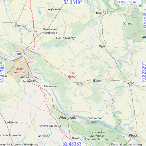
Kikół GPS coordinates[2]
52° 54' 35.784" North, 19° 7' 12.576" East
| Map corner | latitude | longitude |
|---|---|---|
| Upper-left | 53.3319°, | 18.41704° |
| Center: | 52.90994°, | 19.12016° |
| Lower-right: | 52.48383°, | 19.82329° |
| Map W x H: | 94.3×94.3 km | = 58.6×58.6mi |
| max Lat: | 54.83135° ⇑17.5% North |
| Kikół: | 52.90994° |
| min Lat: | ⇓82.5% South 49.21328° |
| min Long | Kikół | max Long |
| 14.20249° | 19.12016° | 24.03723° |
| W 42.2%⇐ | ⇒57.8% E |
Elevation
Elevation of Kikół is 89 m = 292 ft, and this is 102.4 m = 336 ft below average elevation for this country.
| Max E: |
974 m = 3196 ft | 85.2% |
| Avg. | 191.4 m = 628 ft | |
| Kikół | 89 m = 292 ft | |
Min E: |
-3 m = -10 ft | 14.8% |
See also: Poland elevation on elevation.city.
Geographical zone
Kikół is located in North temperate zone (between Tropic of Cancer and the Arctic Circle). Distance of this North polar circle is 1518.1 km =943.3 mi to North.| Distance of | km | miles | from Kikół |
|---|---|---|---|
| North Pole | 4124 | 2562.5 | to North |
| Arctic Circle | 1518.1 | 943.3 | to North |
| Tropic Cancer | 3277.1 | 2036.3 | to South |
| Equator | 5883 | 3655.5 | to South |


Nearby cities:
15 places around Kikół: (largest is in red/bold)
• Bobrowniki
17.9 km =11.1 mi,  216°
216°
• Brzuze
18.7 km =11.6 mi,  30°
30°
• Chrostkowo
9.7 km =6 mi,  67°
67°
• Czernikowo
12.9 km =8 mi,  288°
288°
• Lipno
8.3 km =5.2 mi,  151°
151°
• Lubin
3.1 km =1.9 mi,  345°
345°
• Nieszawa
17 km =10.6 mi,  240°
240°
• Obrowo
17.6 km =10.9 mi, 292°
• Radomin
20.3 km =12.6 mi,  14°
14°
• Rogowo
19.2 km =11.9 mi, 67°
• Skępe
16.5 km =10.3 mi,  106°
106°
• Waganiec
20.4 km =12.7 mi,  233°
233°
• Wielgie
10.4 km =6.5 mi, 352°
• Witkowo
17.1 km =10.6 mi,  166°
166°
• Zbójno
11.2 km =7 mi, 12°
Sources, notices
• [Note1] Compared only with cities in Poland existing in our database
• [Src1] Map data: © OpenStreetMap contributors (CC-BY-SA)
• [Src2] Other city data from geonames.org with taken over terms of usage.
• [Src3] Geographical zone / Annual Mean Temperature by Robert A. Rohde @ Wikipedia
