Nowogrodziec geodata
Nowogrodziec (Lower Silesia) is a seat of a third-order administrative division; located in Poland in Europe/Warsaw (GMT+2) time zone. With population of 4,031 people, there are 809 cities with bigger population in this country. Compared to other cities in Poland, 50.8% of cities are located further ↓South; 96% of cities are located further →East and 62.4% of cities have lower elevation than Nowogrodziec. Note1
Administrative division(s):
- Level 1: Lower Silesia
- Level 2: Powiat bolesławiecki
- Level 3: Nowogrodziec


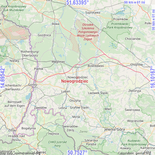
Nowogrodziec GPS coordinates[2]
51° 11' 43.548" North, 15° 23' 54.744" East
| Map corner | latitude | longitude |
|---|---|---|
| Upper-left | 51.63395°, | 14.69542° |
| Center: | 51.19543°, | 15.39854° |
| Lower-right: | 50.7527°, | 16.10167° |
| Map W x H: | 98×98 km | = 60.9×60.9mi |
| max Lat: | 54.83135° ⇑49.2% North |
| Nowogrodziec: | 51.19543° |
| min Lat: | ⇓50.8% South 49.21328° |
| min Long | Nowogrodziec | max Long |
| 14.20249° | 15.39854° | 24.03723° |
| W 4%⇐ | ⇒96% E |
Elevation
Elevation of Nowogrodziec is 207 m = 679 ft, and this is 15.6 m = 51 ft above average elevation for this country.
| Max E: |
974 m = 3196 ft | 37.6% |
| Nowogrodziec | 207 m 679 ft | |
| Avg. | 191.4 m = 628 ft | |
Min E: |
-3 m = -10 ft | 62.4% |
See also: Poland elevation on elevation.city.
Geographical zone
Nowogrodziec is located in North temperate zone (between Tropic of Cancer and the Arctic Circle). Distance of this North polar circle is 1708.8 km =1061.8 mi to North.| Distance of | km | miles | from Nowogrodziec |
|---|---|---|---|
| North Pole | 4314.7 | 2681 | to North |
| Arctic Circle | 1708.8 | 1061.8 | to North |
| Tropic Cancer | 3086.5 | 1917.9 | to South |
| Equator | 5692.4 | 3537.1 | to South |


Nearby cities:
15 places around Nowogrodziec: (largest is in red/bold)
• Bolesławiec
14.2 km =8.8 mi,  57°
57°
• Gryfów Śląski
18.4 km =11.4 mi,  175°
175°
• Leśna
21.2 km =13.2 mi,  206°
206°
• Lubań
11.4 km =7.1 mi,  222°
222°
• Lubomierz
21.7 km =13.5 mi,  159°
159°
• Lwówek Śląski
16.1 km =10 mi,  125°
125°
• Mirsk
25 km =15.5 mi, 182°
• Olszyna
14.4 km =8.9 mi,  187°
187°
• Osiecznica
14.7 km =9.1 mi,  5°
5°
• Pisarzowice
13 km =8.1 mi,  244°
244°
• Platerówka
21.8 km =13.5 mi,  226°
226°
• Siekierczyn
16.4 km =10.2 mi, 240°
• Warta Bolesławiecka
19.2 km =11.9 mi,  77°
77°
• Węgliniec
15.6 km =9.7 mi,  310°
310°
• Łaziska
15.4 km =9.6 mi,  71°
71°
Sources, notices
• [Note1] Compared only with cities in Poland existing in our database
• [Src1] Map data: © OpenStreetMap contributors (CC-BY-SA)
• [Src2] Other city data from geonames.org with taken over terms of usage.
• [Src3] Geographical zone / Annual Mean Temperature by Robert A. Rohde @ Wikipedia
