Gryfów Śląski geodata
Gryfów Śląski (Lower Silesia) is a seat of a third-order administrative division; located in Poland in Europe/Warsaw (GMT+2) time zone. With population of 6,890 people, there are 549 cities with bigger population in this country. Compared to other cities in Poland, 54.5% of cities are located further ↑North; 95.8% of cities are located further →East and 89.6% of cities have lower elevation than Gryfów Śląski. Note1


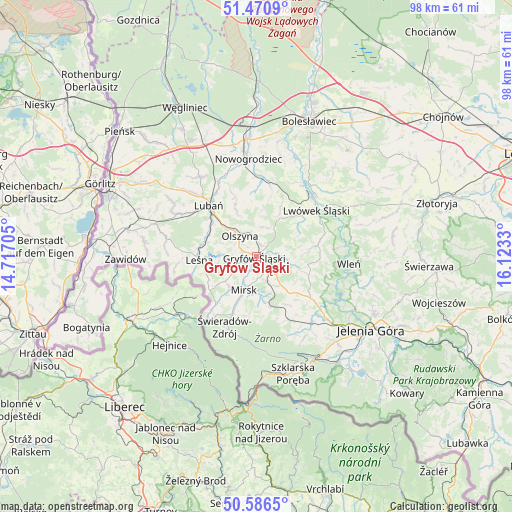
Gryfów Śląski GPS coordinates[2]
51° 1' 50.916" North, 15° 25' 12.612" East
| Map corner | latitude | longitude |
|---|---|---|
| Upper-left | 51.4709°, | 14.71705° |
| Center: | 51.03081°, | 15.42017° |
| Lower-right: | 50.5865°, | 16.1233° |
| Map W x H: | 98.3×98.3 km | = 61.1×61.1mi |
| max Lat: | 54.83135° ⇑54.5% North |
| Gryfów Śląski: | 51.03081° |
| min Lat: | ⇓45.5% South 49.21328° |
| min Long | Gryfów Śląsk | max Long |
| 14.20249° | 15.42017° | 24.03723° |
| W 4.2%⇐ | ⇒95.8% E |
Elevation
Elevation of Gryfów Śląski is 322 m = 1056 ft, and this is 130.6 m = 428 ft above average elevation for this country.
| Max E: |
974 m = 3196 ft | 10.4% |
| Gryfów Śląski | 322 m 1056 ft | |
| Avg. | 191.4 m = 628 ft | |
Min E: |
-3 m = -10 ft | 89.6% |
See also: Poland elevation on elevation.city.
Geographical zone
Gryfów Śląski is located in North temperate zone (between Tropic of Cancer and the Arctic Circle). Distance of this North polar circle is 1727.1 km =1073.2 mi to North.| Distance of | km | miles | from Gryfów Śląski |
|---|---|---|---|
| North Pole | 4333 | 2692.4 | to North |
| Arctic Circle | 1727.1 | 1073.2 | to North |
| Tropic Cancer | 3068.2 | 1906.5 | to South |
| Equator | 5674.1 | 3525.7 | to South |


Nearby cities:
15 places around Gryfów Śląski: (largest is in red/bold)
• Leśna
10.9 km =6.8 mi,  266°
266°
• Lubań
13.6 km =8.5 mi,  317°
317°
• Lubomierz
6.6 km =4.1 mi,  107°
107°
• Lwówek Śląski
14.6 km =9.1 mi,  52°
52°
• Mirsk
7.1 km =4.4 mi,  199°
199°
• Nowogrodziec
18.4 km =11.4 mi,  355°
355°
• Olszyna
5.2 km =3.2 mi, 320°
• Pasiecznik
13.4 km =8.3 mi,  127°
127°
• Pilchowice
16.3 km =10.1 mi, 110°
• Pisarzowice
18.3 km =11.4 mi,  313°
313°
• Platerówka
17.6 km =10.9 mi,  280°
280°
• Siekierczyn
18.8 km =11.7 mi,  302°
302°
• Stara Kamienica
16.6 km =10.3 mi,  140°
140°
• Wleń
17.9 km =11.1 mi,  95°
95°
• Świeradów-Zdrój
14.6 km =9.1 mi, 201°
Sources, notices
• [Note1] Compared only with cities in Poland existing in our database
• [Src1] Map data: © OpenStreetMap contributors (CC-BY-SA)
• [Src2] Other city data from geonames.org with taken over terms of usage.
• [Src3] Geographical zone / Annual Mean Temperature by Robert A. Rohde @ Wikipedia
