Węgliniec geodata
Węgliniec (Lower Silesia) is a seat of a third-order administrative division; located in Poland in Europe/Warsaw (GMT+2) time zone. With population of 2,992 people, there are 1055 cities with bigger population in this country. Compared to other cities in Poland, 52.9% of cities are located further ↓South; 96.8% of cities are located further →East and 57.5% of cities have lower elevation than Węgliniec. Note1


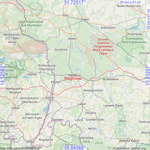
Węgliniec GPS coordinates[2]
51° 17' 15.108" North, 15° 13' 44.184" East
| Map corner | latitude | longitude |
|---|---|---|
| Upper-left | 51.72517°, | 14.52582° |
| Center: | 51.28753°, | 15.22894° |
| Lower-right: | 50.84568°, | 15.93207° |
| Map W x H: | 97.8×97.8 km | = 60.8×60.8mi |
| max Lat: | 54.83135° ⇑47.1% North |
| Węgliniec: | 51.28753° |
| min Lat: | ⇓52.9% South 49.21328° |
| min Long | Węgliniec | max Long |
| 14.20249° | 15.22894° | 24.03723° |
| W 3.2%⇐ | ⇒96.8% E |
Elevation
Elevation of Węgliniec is 192 m = 630 ft, and this is 0.59999999999999 m = 2 ft above average elevation for this country.
| Max E: |
974 m = 3196 ft | 42.5% |
| Węgliniec | 192 m 630 ft | |
| Avg. | 191.4 m = 628 ft | |
Min E: |
-3 m = -10 ft | 57.5% |
See also: Poland elevation on elevation.city.
Geographical zone
Węgliniec is located in North temperate zone (between Tropic of Cancer and the Arctic Circle). Distance of this North polar circle is 1698.5 km =1055.4 mi to North.| Distance of | km | miles | from Węgliniec |
|---|---|---|---|
| North Pole | 4304.4 | 2674.6 | to North |
| Arctic Circle | 1698.5 | 1055.4 | to North |
| Tropic Cancer | 3096.7 | 1924.2 | to South |
| Equator | 5702.6 | 3543.4 | to South |


Nearby cities:
15 places around Węgliniec: (largest is in red/bold)
• Bolesławiec
23.8 km =14.8 mi,  96°
96°
• Gozdnica
18.9 km =11.7 mi,  331°
331°
• Iłowa
23.8 km =14.8 mi,  355°
355°
• Jędrzychowice
18.7 km =11.6 mi,  232°
232°
• Lubań
19.1 km =11.9 mi,  167°
167°
• Nowogrodziec
15.6 km =9.7 mi,  130°
130°
• Olszyna
26.5 km =16.5 mi,  157°
157°
• Osiecznica
14 km =8.7 mi,  71°
71°
• Pieńsk
13.4 km =8.3 mi,  251°
251°
• Pisarzowice
15.9 km =9.9 mi,  179°
179°
• Platerówka
25.6 km =15.9 mi,  188°
188°
• Siekierczyn
18.5 km =11.5 mi, 187°
• Sulików
26 km =16.2 mi,  205°
205°
• Zgorzelec
21.7 km =13.5 mi, 225°
• Łagów
19.3 km =12 mi,  221°
221°
Sources, notices
• [Note1] Compared only with cities in Poland existing in our database
• [Src1] Map data: © OpenStreetMap contributors (CC-BY-SA)
• [Src2] Other city data from geonames.org with taken over terms of usage.
• [Src3] Geographical zone / Annual Mean Temperature by Robert A. Rohde @ Wikipedia
