Łaziska geodata
Łaziska (Lower Silesia) is a populated place; located in Poland in Europe/Warsaw (GMT+2) time zone. With population of 560 people, there are 3377 cities with bigger population in this country. Compared to other cities in Poland, 51.8% of cities are located further ↓South; 94.8% of cities are located further →East and 67.7% of cities have lower elevation than Łaziska. Note1
Administrative division(s):
- Level 1: Lower Silesia
- Level 2: Powiat bolesławiecki
- Level 3: Bolesławiec


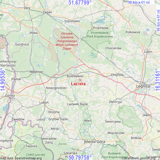
Łaziska GPS coordinates[2]
51° 14' 23.604" North, 15° 36' 30.528" East
| Map corner | latitude | longitude |
|---|---|---|
| Upper-left | 51.67799°, | 14.90536° |
| Center: | 51.23989°, | 15.60848° |
| Lower-right: | 50.79758°, | 16.31161° |
| Map W x H: | 97.9×97.9 km | = 60.8×60.8mi |
| max Lat: | 54.83135° ⇑48.2% North |
| Łaziska: | 51.23989° |
| min Lat: | ⇓51.8% South 49.21328° |
| min Long | Łaziska | max Long |
| 14.20249° | 15.60848° | 24.03723° |
| W 5.2%⇐ | ⇒94.8% E |
Elevation
Elevation of Łaziska is 222 m = 728 ft, and this is 30.6 m = 100 ft above average elevation for this country.
| Max E: |
974 m = 3196 ft | 32.3% |
| Łaziska | 222 m 728 ft | |
| Avg. | 191.4 m = 628 ft | |
Min E: |
-3 m = -10 ft | 67.7% |
See also: Poland elevation on elevation.city.
Geographical zone
Łaziska is located in North temperate zone (between Tropic of Cancer and the Arctic Circle). Distance of this North polar circle is 1703.8 km =1058.7 mi to North.| Distance of | km | miles | from Łaziska |
|---|---|---|---|
| North Pole | 4309.7 | 2677.9 | to North |
| Arctic Circle | 1703.8 | 1058.7 | to North |
| Tropic Cancer | 3091.4 | 1920.9 | to South |
| Equator | 5697.3 | 3540.1 | to South |


Nearby cities:
15 places around Łaziska: (largest is in red/bold)
• Bolesławiec
3.8 km =2.4 mi,  315°
315°
• Chojnów
23.1 km =14.4 mi,  80°
80°
• Gromadka
17.3 km =10.7 mi,  38°
38°
• Krzywa
14.9 km =9.3 mi,  71°
71°
• Lubań
26 km =16.2 mi,  239°
239°
• Lwówek Śląski
14.4 km =8.9 mi,  186°
186°
• Nowogrodziec
15.4 km =9.6 mi,  251°
251°
• Olszanica
13.9 km =8.6 mi,  105°
105°
• Olszyna
25.3 km =15.7 mi,  220°
220°
• Osiecznica
16.3 km =10.1 mi,  306°
306°
• Pielgrzymka
19.9 km =12.4 mi,  133°
133°
• Warta Bolesławiecka
4.2 km =2.6 mi,  102°
102°
• Wleń
25.3 km =15.7 mi,  169°
169°
• Zagrodno
18.7 km =11.6 mi, 106°
• Złotoryja
25.1 km =15.6 mi,  120°
120°
Sources, notices
• [Note1] Compared only with cities in Poland existing in our database
• [Src1] Map data: © OpenStreetMap contributors (CC-BY-SA)
• [Src2] Other city data from geonames.org with taken over terms of usage.
• [Src3] Geographical zone / Annual Mean Temperature by Robert A. Rohde @ Wikipedia
