Platerówka geodata
Platerówka (Lower Silesia) is a populated place; located in Poland in Europe/Warsaw (GMT+2) time zone. With population of 580 people, there are 3338 cities with bigger population in this country. Compared to other cities in Poland, 53.7% of cities are located further ↑North; 97% of cities are located further →East and 85.8% of cities have lower elevation than Platerówka. Note1


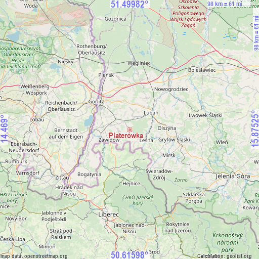
Platerówka GPS coordinates[2]
51° 3' 36.036" North, 15° 10' 19.632" East
| Map corner | latitude | longitude |
|---|---|---|
| Upper-left | 51.49982°, | 14.469° |
| Center: | 51.06001°, | 15.17212° |
| Lower-right: | 50.61598°, | 15.87525° |
| Map W x H: | 98.3×98.3 km | = 61.1×61.1mi |
| max Lat: | 54.83135° ⇑53.7% North |
| Platerówka: | 51.06001° |
| min Lat: | ⇓46.3% South 49.21328° |
| min Long | Platerówka | max Long |
| 14.20249° | 15.17212° | 24.03723° |
| W 3%⇐ | ⇒97% E |
Elevation
Elevation of Platerówka is 294 m = 965 ft, and this is 102.6 m = 337 ft above average elevation for this country.
| Max E: |
974 m = 3196 ft | 14.2% |
| Platerówka | 294 m 965 ft | |
| Avg. | 191.4 m = 628 ft | |
Min E: |
-3 m = -10 ft | 85.8% |
See also: Poland elevation on elevation.city.
Geographical zone
Platerówka is located in North temperate zone (between Tropic of Cancer and the Arctic Circle). Distance of this North polar circle is 1723.8 km =1071.1 mi to North.| Distance of | km | miles | from Platerówka |
|---|---|---|---|
| North Pole | 4329.7 | 2690.4 | to North |
| Arctic Circle | 1723.8 | 1071.1 | to North |
| Tropic Cancer | 3071.4 | 1908.5 | to South |
| Equator | 5677.3 | 3527.7 | to South |


Nearby cities:
15 places around Platerówka: (largest is in red/bold)
• Bogatynia
22.7 km =14.1 mi,  221°
221°
• Gryfów Śląski
17.6 km =10.9 mi,  100°
100°
• Jędrzychowice
17.6 km =10.9 mi,  321°
321°
• Leśna
7.6 km =4.7 mi,  121°
121°
• Lubań
10.5 km =6.5 mi,  50°
50°
• Mirsk
17.9 km =11.1 mi, 123°
• Nowogrodziec
21.8 km =13.5 mi, 46°
• Olszyna
14 km =8.7 mi,  86°
86°
• Pisarzowice
10.3 km =6.4 mi,  23°
23°
• Siekierczyn
7.1 km =4.4 mi,  12°
12°
• Sulików
7.5 km =4.7 mi,  283°
283°
• Zawidów
8.6 km =5.3 mi,  243°
243°
• Zgorzelec
15.2 km =9.4 mi,  311°
311°
• Łagów
14.1 km =8.8 mi, 320°
• Świeradów-Zdrój
20.6 km =12.8 mi,  144°
144°
Sources, notices
• [Note1] Compared only with cities in Poland existing in our database
• [Src1] Map data: © OpenStreetMap contributors (CC-BY-SA)
• [Src2] Other city data from geonames.org with taken over terms of usage.
• [Src3] Geographical zone / Annual Mean Temperature by Robert A. Rohde @ Wikipedia
