Kowary geodata
Kowary (Lower Silesia) is a populated place; located in Poland in Europe/Warsaw (GMT+2) time zone. With population of 11,834 people, there are 400 cities with bigger population in this country. Compared to other cities in Poland, 60.3% of cities are located further ↑North; 93.3% of cities are located further →East and 96.7% of cities have lower elevation than Kowary. Note1


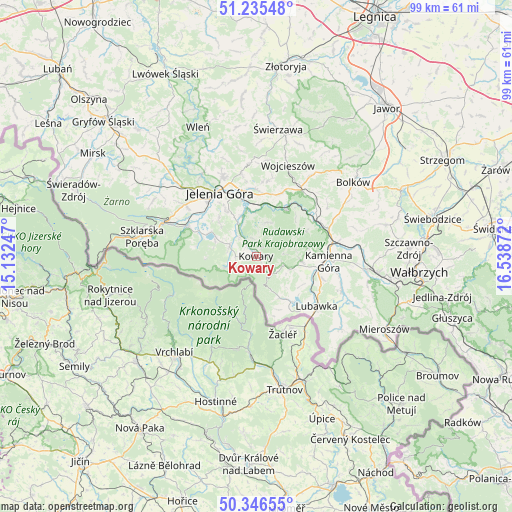
Kowary GPS coordinates[2]
50° 47' 35.268" North, 15° 50' 8.124" East
| Map corner | latitude | longitude |
|---|---|---|
| Upper-left | 51.23548°, | 15.13247° |
| Center: | 50.79313°, | 15.83559° |
| Lower-right: | 50.34655°, | 16.53872° |
| Map W x H: | 98.8×98.8 km | = 61.4×61.4mi |
| max Lat: | 54.83135° ⇑60.3% North |
| Kowary: | 50.79313° |
| min Lat: | ⇓39.7% South 49.21328° |
| min Long | Kowary | max Long |
| 14.20249° | 15.83559° | 24.03723° |
| W 6.7%⇐ | ⇒93.3% E |
Elevation
Elevation of Kowary is 463 m = 1519 ft, and this is 271.6 m = 891 ft above average elevation for this country.
| Max E: |
974 m = 3196 ft | 3.3% |
| Kowary | 463 m 1519 ft | |
| Avg. | 191.4 m = 628 ft | |
Min E: |
-3 m = -10 ft | 96.7% |
See also: Poland elevation on elevation.city.
Geographical zone
Kowary is located in North temperate zone (between Tropic of Cancer and the Arctic Circle). Distance of this North polar circle is 1753.5 km =1089.6 mi to North.| Distance of | km | miles | from Kowary |
|---|---|---|---|
| North Pole | 4359.4 | 2708.8 | to North |
| Arctic Circle | 1753.5 | 1089.6 | to North |
| Tropic Cancer | 3041.7 | 1890 | to South |
| Equator | 5647.7 | 3509.3 | to South |


Nearby cities:
15 places around Kowary: (largest is in red/bold)
• Cieplice Śląskie Zdrój
13.4 km =8.3 mi,  307°
307°
• Janowice Wielkie
11.1 km =6.9 mi,  33°
33°
• Jelenia Góra
14 km =8.7 mi,  327°
327°
• Jeżów Sudecki
17.1 km =10.6 mi,  337°
337°
• Kamienna Góra
13.7 km =8.5 mi,  94°
94°
• Karpacz
5.9 km =3.7 mi,  251°
251°
• Krzeszów
17.7 km =11 mi,  111°
111°
• Lubawka
15.2 km =9.4 mi,  130°
130°
• Marciszów
14.2 km =8.8 mi,  66°
66°
• Mysłakowice
6.7 km =4.2 mi,  323°
323°
• Piechowice
17.8 km =11.1 mi,  290°
290°
• Podgórzyn
11.7 km =7.3 mi, 292°
• Rybnica
20.4 km =12.7 mi, 312°
• Sosnówka
8.4 km =5.2 mi, 289°
• Wojcieszów
18.7 km =11.6 mi,  18°
18°
Sources, notices
• [Note1] Compared only with cities in Poland existing in our database
• [Src1] Map data: © OpenStreetMap contributors (CC-BY-SA)
• [Src2] Other city data from geonames.org with taken over terms of usage.
• [Src3] Geographical zone / Annual Mean Temperature by Robert A. Rohde @ Wikipedia
