Baranówka geodata
Baranówka (Lesser Poland) is a populated place; located in Poland in Europe/Warsaw (GMT+2) time zone. With population of 750 people, there are 2953 cities with bigger population in this country. Compared to other cities in Poland, 76.3% of cities are located further ↑North; 60% of cities are located further ←West and 77.6% of cities have lower elevation than Baranówka. Note1
Administrative division(s):
- Level 1: Lesser Poland
- Level 2: Powiat krakowski
- Level 3: Kocmyrzów-Luborzyca


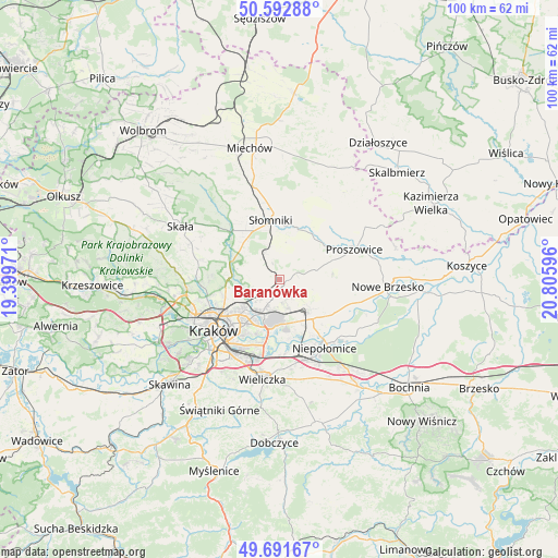
Baranówka GPS coordinates[2]
50° 8' 39.84" North, 20° 6' 10.188" East
| Map corner | latitude | longitude |
|---|---|---|
| Upper-left | 50.59288°, | 19.39971° |
| Center: | 50.1444°, | 20.10283° |
| Lower-right: | 49.69167°, | 20.80596° |
| Map W x H: | 100.2×100.2 km | = 62.3×62.3mi |
| max Lat: | 54.83135° ⇑76.3% North |
| Baranówka: | 50.1444° |
| min Lat: | ⇓23.7% South 49.21328° |
| min Long | Baranówka | max Long |
| 14.20249° | 20.10283° | 24.03723° |
| W 60%⇐ | ⇒40% E |
Elevation
Elevation of Baranówka is 256 m = 840 ft, and this is 64.6 m = 212 ft above average elevation for this country.
| Max E: |
974 m = 3196 ft | 22.4% |
| Baranówka | 256 m 840 ft | |
| Avg. | 191.4 m = 628 ft | |
Min E: |
-3 m = -10 ft | 77.6% |
See also: Poland elevation on elevation.city.
Geographical zone
Baranówka is located in North temperate zone (between Tropic of Cancer and the Arctic Circle). Distance of this North polar circle is 1825.6 km =1134.4 mi to North.| Distance of | km | miles | from Baranówka |
|---|---|---|---|
| North Pole | 4431.5 | 2753.6 | to North |
| Arctic Circle | 1825.6 | 1134.4 | to North |
| Tropic Cancer | 2969.6 | 1845.2 | to South |
| Equator | 5575.5 | 3464.5 | to South |


Nearby cities:
15 places around Baranówka: (largest is in red/bold)
• Dojazdów
2.6 km =1.6 mi,  164°
164°
• Iwanowice
13.6 km =8.5 mi,  312°
312°
• Kocmyrzów
2.6 km =1.6 mi,  128°
128°
• Kokotów
14.8 km =9.2 mi,  186°
186°
• Luborzyca
1.3 km =0.8 mi,  139°
139°
• Masłomiąca
7.5 km =4.7 mi,  284°
284°
• Michałowice
8.9 km =5.5 mi, 280°
• Miłocice
10.7 km =6.6 mi,  336°
336°
• Niedźwiedź
8.9 km =5.5 mi,  355°
355°
• Niepołomice
14.4 km =8.9 mi, 143°
• Proszowice
14.3 km =8.9 mi,  67°
67°
• Sieciechowice
14.4 km =8.9 mi,  320°
320°
• Słomniki
10.7 km =6.6 mi,  352°
352°
• Węgrzce Wielkie
14.4 km =8.9 mi,  177°
177°
• Zielonki
13.2 km =8.2 mi,  258°
258°
Sources, notices
• [Note1] Compared only with cities in Poland existing in our database
• [Src1] Map data: © OpenStreetMap contributors (CC-BY-SA)
• [Src2] Other city data from geonames.org with taken over terms of usage.
• [Src3] Geographical zone / Annual Mean Temperature by Robert A. Rohde @ Wikipedia
