Marcówka geodata
Marcówka (Lesser Poland) is a populated place; located in Poland in Europe/Warsaw (GMT+2) time zone. With population of 609 people, there are 3256 cities with bigger population in this country. Compared to other cities in Poland, 92% of cities are located further ↑North; 51.1% of cities are located further ←West and 96.4% of cities have lower elevation than Marcówka. Note1


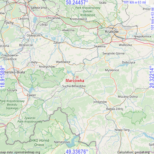
Marcówka GPS coordinates[2]
49° 47' 34.044" North, 19° 37' 8.436" East
| Map corner | latitude | longitude |
|---|---|---|
| Upper-left | 50.24457°, | 18.91589° |
| Center: | 49.79279°, | 19.61901° |
| Lower-right: | 49.33676°, | 20.32214° |
| Map W x H: | 100.9×100.9 km | = 62.7×62.7mi |
| max Lat: | 54.83135° ⇑92% North |
| Marcówka: | 49.79279° |
| min Lat: | ⇓8% South 49.21328° |
| min Long | Marcówka | max Long |
| 14.20249° | 19.61901° | 24.03723° |
| W 51.1%⇐ | ⇒48.9% E |
Elevation
Elevation of Marcówka is 452 m = 1483 ft, and this is 260.6 m = 855 ft above average elevation for this country.
| Max E: |
974 m = 3196 ft | 3.6% |
| Marcówka | 452 m 1483 ft | |
| Avg. | 191.4 m = 628 ft | |
Min E: |
-3 m = -10 ft | 96.4% |
See also: Poland elevation on elevation.city.
Geographical zone
Marcówka is located in North temperate zone (between Tropic of Cancer and the Arctic Circle). Distance of this North polar circle is 1864.7 km =1158.7 mi to North.| Distance of | km | miles | from Marcówka |
|---|---|---|---|
| North Pole | 4470.6 | 2777.9 | to North |
| Arctic Circle | 1864.7 | 1158.7 | to North |
| Tropic Cancer | 2930.5 | 1820.9 | to South |
| Equator | 5536.4 | 3440.2 | to South |


Nearby cities:
15 places around Marcówka: (largest is in red/bold)
• Baczyn
7.3 km =4.5 mi,  90°
90°
• Barwałd Górny
7.7 km =4.8 mi,  359°
359°
• Barwałd Średni
8.4 km =5.2 mi,  347°
347°
• Budzów
4.3 km =2.7 mi,  115°
115°
• Jachówka
6.7 km =4.2 mi,  125°
125°
• Maków Podhalański
8.1 km =5 mi,  149°
149°
• Mucharz
5.6 km =3.5 mi,  292°
292°
• Skawinki
7.5 km =4.7 mi,  63°
63°
• Stronie
5.8 km =3.6 mi,  43°
43°
• Stryszów
3.7 km =2.3 mi, 358°
• Sucha Beskidzka
5.9 km =3.7 mi,  197°
197°
• Zachełmna
5.1 km =3.2 mi,  82°
82°
• Zakrzów
4.3 km =2.7 mi,  31°
31°
• Zembrzyce
2.3 km =1.4 mi,  213°
213°
• Świnna Poręba
8.5 km =5.3 mi,  304°
304°
Sources, notices
• [Note1] Compared only with cities in Poland existing in our database
• [Src1] Map data: © OpenStreetMap contributors (CC-BY-SA)
• [Src2] Other city data from geonames.org with taken over terms of usage.
• [Src3] Geographical zone / Annual Mean Temperature by Robert A. Rohde @ Wikipedia
