Sucha Beskidzka geodata
Sucha Beskidzka (Lesser Poland) is a seat of a second-order administrative division; located in Poland in Europe/Warsaw (GMT+2) time zone. With population of 9,801 people, there are 453 cities with bigger population in this country. Compared to other cities in Poland, 93.3% of cities are located further ↑North; 50.6% of cities are located further ←West and 90.6% of cities have lower elevation than Sucha Beskidzka. Note1


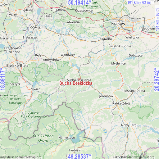
Sucha Beskidzka GPS coordinates[2]
49° 44' 30.768" North, 19° 35' 39.444" East
| Map corner | latitude | longitude |
|---|---|---|
| Upper-left | 50.19414°, | 18.89117° |
| Center: | 49.74188°, | 19.59429° |
| Lower-right: | 49.28537°, | 20.29742° |
| Map W x H: | 101×101 km | = 62.8×62.8mi |
| max Lat: | 54.83135° ⇑93.3% North |
| Sucha Beskidzka: | 49.74188° |
| min Lat: | ⇓6.7% South 49.21328° |
| min Long | Sucha Beskidzka | max Long |
| 14.20249° | 19.59429° | 24.03723° |
| W 50.6%⇐ | ⇒49.4% E |
Elevation
Elevation of Sucha Beskidzka is 338 m = 1109 ft, and this is 146.6 m = 481 ft above average elevation for this country.
| Max E: |
974 m = 3196 ft | 9.4% |
| Sucha Beskidzka | 338 m 1109 ft | |
| Avg. | 191.4 m = 628 ft | |
Min E: |
-3 m = -10 ft | 90.6% |
See also: Poland elevation on elevation.city.
Geographical zone
Sucha Beskidzka is located in North temperate zone (between Tropic of Cancer and the Arctic Circle). Distance of this North polar circle is 1870.4 km =1162.2 mi to North.| Distance of | km | miles | from Sucha Beskidzka |
|---|---|---|---|
| North Pole | 4476.3 | 2781.4 | to North |
| Arctic Circle | 1870.4 | 1162.2 | to North |
| Tropic Cancer | 2924.9 | 1817.4 | to South |
| Equator | 5530.8 | 3436.7 | to South |


Nearby cities:
15 places around Sucha Beskidzka: (largest is in red/bold)
• Białka
7.7 km =4.8 mi,  134°
134°
• Budzów
6.8 km =4.2 mi,  55°
55°
• Grzechynia
4.8 km =3 mi, 130°
• Jachówka
7.4 km =4.6 mi,  75°
75°
• Juszczyn
8.8 km =5.5 mi, 127°
• Krzeszów
7.8 km =4.8 mi,  284°
284°
• Kuków
7.9 km =4.9 mi,  262°
262°
• Lachowice
9.1 km =5.7 mi,  251°
251°
• Maków Podhalański
6.1 km =3.8 mi,  102°
102°
• Marcówka
5.9 km =3.7 mi,  17°
17°
• Mucharz
8.5 km =5.3 mi,  336°
336°
• Skawica
7.5 km =4.7 mi,  163°
163°
• Stryszawa
6.1 km =3.8 mi,  238°
238°
• Zachełmna
9.3 km =5.8 mi,  46°
46°
• Zembrzyce
3.7 km =2.3 mi,  7°
7°
Sources, notices
• [Note1] Compared only with cities in Poland existing in our database
• [Src1] Map data: © OpenStreetMap contributors (CC-BY-SA)
• [Src2] Other city data from geonames.org with taken over terms of usage.
• [Src3] Geographical zone / Annual Mean Temperature by Robert A. Rohde @ Wikipedia
