Zembrzyce geodata
Zembrzyce (Lesser Poland) is a seat of a third-order administrative division; located in Poland in Europe/Warsaw (GMT+2) time zone. With population of 2,900 people, there are 1090 cities with bigger population in this country. Compared to other cities in Poland, 92.6% of cities are located further ↑North; 50.7% of cities are located further ←West and 88.9% of cities have lower elevation than Zembrzyce. Note1


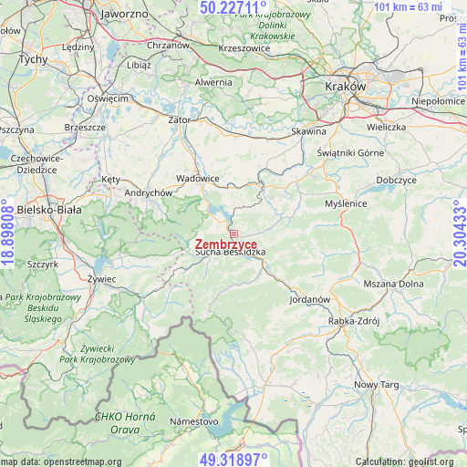
Zembrzyce GPS coordinates[2]
49° 46' 30.612" North, 19° 36' 4.32" East
| Map corner | latitude | longitude |
|---|---|---|
| Upper-left | 50.22711°, | 18.89808° |
| Center: | 49.77517°, | 19.6012° |
| Lower-right: | 49.31897°, | 20.30433° |
| Map W x H: | 101×101 km | = 62.8×62.8mi |
| max Lat: | 54.83135° ⇑92.6% North |
| Zembrzyce: | 49.77517° |
| min Lat: | ⇓7.4% South 49.21328° |
| min Long | Zembrzyce | max Long |
| 14.20249° | 19.6012° | 24.03723° |
| W 50.7%⇐ | ⇒49.3% E |
Elevation
Elevation of Zembrzyce is 316 m = 1037 ft, and this is 124.6 m = 409 ft above average elevation for this country.
| Max E: |
974 m = 3196 ft | 11.1% |
| Zembrzyce | 316 m 1037 ft | |
| Avg. | 191.4 m = 628 ft | |
Min E: |
-3 m = -10 ft | 88.9% |
See also: Poland elevation on elevation.city.
Geographical zone
Zembrzyce is located in North temperate zone (between Tropic of Cancer and the Arctic Circle). Distance of this North polar circle is 1866.7 km =1159.9 mi to North.| Distance of | km | miles | from Zembrzyce |
|---|---|---|---|
| North Pole | 4472.6 | 2779.1 | to North |
| Arctic Circle | 1866.7 | 1159.9 | to North |
| Tropic Cancer | 2928.6 | 1819.7 | to South |
| Equator | 5534.5 | 3439 | to South |


Nearby cities:
15 places around Zembrzyce: (largest is in red/bold)
• Baczyn
8.8 km =5.5 mi,  77°
77°
• Budzów
5.1 km =3.2 mi,  88°
88°
• Grzechynia
7.6 km =4.7 mi,  155°
155°
• Jachówka
7 km =4.3 mi,  105°
105°
• Krzeszów
8.2 km =5.1 mi,  257°
257°
• Maków Podhalański
7.4 km =4.6 mi,  132°
132°
• Marcówka
2.3 km =1.4 mi,  33°
33°
• Mucharz
5.6 km =3.5 mi,  316°
316°
• Stronie
8.1 km =5 mi,  40°
40°
• Stryszawa
8.9 km =5.5 mi,  219°
219°
• Stryszów
5.7 km =3.5 mi,  11°
11°
• Sucha Beskidzka
3.7 km =2.3 mi,  187°
187°
• Zachełmna
6.8 km =4.2 mi,  67°
67°
• Zakrzów
6.6 km =4.1 mi, 31°
• Świnna Poręba
8.9 km =5.5 mi, 319°
Sources, notices
• [Note1] Compared only with cities in Poland existing in our database
• [Src1] Map data: © OpenStreetMap contributors (CC-BY-SA)
• [Src2] Other city data from geonames.org with taken over terms of usage.
• [Src3] Geographical zone / Annual Mean Temperature by Robert A. Rohde @ Wikipedia
