Mucharz geodata
Mucharz (Silesia) is a populated place; located in Poland in Europe/Warsaw (GMT+2) time zone. With population of 830 people, there are 2797 cities with bigger population in this country. Compared to other cities in Poland, 91.3% of cities are located further ↑North; 50.3% of cities are located further →East and 88.5% of cities have lower elevation than Mucharz. Note1


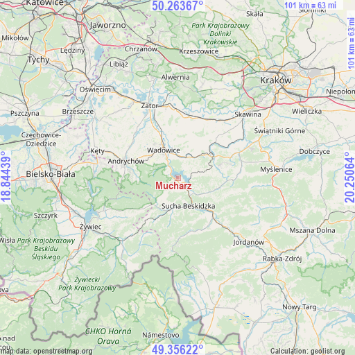
Mucharz GPS coordinates[2]
49° 48' 43.452" North, 19° 32' 51.036" East
| Map corner | latitude | longitude |
|---|---|---|
| Upper-left | 50.26367°, | 18.84439° |
| Center: | 49.81207°, | 19.54751° |
| Lower-right: | 49.35622°, | 20.25064° |
| Map W x H: | 100.9×100.9 km | = 62.7×62.7mi |
| max Lat: | 54.83135° ⇑91.3% North |
| Mucharz: | 49.81207° |
| min Lat: | ⇓8.7% South 49.21328° |
| min Long | Mucharz | max Long |
| 14.20249° | 19.54751° | 24.03723° |
| W 49.7%⇐ | ⇒50.3% E |
Elevation
Elevation of Mucharz is 313 m = 1027 ft, and this is 121.6 m = 399 ft above average elevation for this country.
| Max E: |
974 m = 3196 ft | 11.5% |
| Mucharz | 313 m 1027 ft | |
| Avg. | 191.4 m = 628 ft | |
Min E: |
-3 m = -10 ft | 88.5% |
See also: Poland elevation on elevation.city.
Geographical zone
Mucharz is located in North temperate zone (between Tropic of Cancer and the Arctic Circle). Distance of this North polar circle is 1862.6 km =1157.4 mi to North.| Distance of | km | miles | from Mucharz |
|---|---|---|---|
| North Pole | 4468.5 | 2776.6 | to North |
| Arctic Circle | 1862.6 | 1157.4 | to North |
| Tropic Cancer | 2932.7 | 1822.3 | to South |
| Equator | 5538.6 | 3441.5 | to South |


Nearby cities:
15 places around Mucharz: (largest is in red/bold)
• Barwałd Dolny
6.3 km =3.9 mi,  15°
15°
• Barwałd Górny
7.5 km =4.7 mi,  42°
42°
• Barwałd Średni
6.9 km =4.3 mi,  28°
28°
• Jaroszowice
6 km =3.7 mi,  340°
340°
• Klecza Dolna
7.9 km =4.9 mi,  354°
354°
• Klecza Górna
5.9 km =3.7 mi,  6°
6°
• Krzeszów
7.2 km =4.5 mi,  215°
215°
• Marcówka
5.6 km =3.5 mi,  112°
112°
• Ponikiew
6.3 km =3.9 mi,  291°
291°
• Stryszów
5.3 km =3.3 mi,  73°
73°
• Sucha Beskidzka
8.5 km =5.3 mi,  156°
156°
• Wadowice
8.8 km =5.5 mi,  333°
333°
• Zakrzów
7.5 km =4.7 mi,  78°
78°
• Zembrzyce
5.6 km =3.5 mi,  136°
136°
• Świnna Poręba
3.3 km =2.1 mi, 325°
Sources, notices
• [Note1] Compared only with cities in Poland existing in our database
• [Src1] Map data: © OpenStreetMap contributors (CC-BY-SA)
• [Src2] Other city data from geonames.org with taken over terms of usage.
• [Src3] Geographical zone / Annual Mean Temperature by Robert A. Rohde @ Wikipedia
