Lędziny geodata
Lędziny (Silesia) is a seat of a third-order administrative division; located in Poland in Europe/Warsaw (GMT+2) time zone. With population of 16,305 people, there are 307 cities with bigger population in this country. Compared to other cities in Poland, 76.4% of cities are located further ↑North; 57.6% of cities are located further →East and 79.4% of cities have lower elevation than Lędziny. Note1


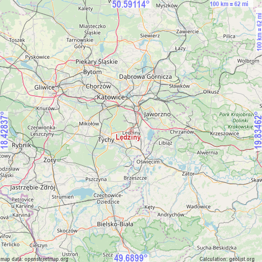
Lędziny GPS coordinates[2]
50° 8' 33.504" North, 19° 7' 53.364" East
| Map corner | latitude | longitude |
|---|---|---|
| Upper-left | 50.59114°, | 18.42837° |
| Center: | 50.14264°, | 19.13149° |
| Lower-right: | 49.6899°, | 19.83462° |
| Map W x H: | 100.2×100.2 km | = 62.3×62.3mi |
| max Lat: | 54.83135° ⇑76.4% North |
| Lędziny: | 50.14264° |
| min Lat: | ⇓23.6% South 49.21328° |
| min Long | Lędziny | max Long |
| 14.20249° | 19.13149° | 24.03723° |
| W 42.4%⇐ | ⇒57.6% E |
Elevation
Elevation of Lędziny is 263 m = 863 ft, and this is 71.6 m = 235 ft above average elevation for this country.
| Max E: |
974 m = 3196 ft | 20.6% |
| Lędziny | 263 m 863 ft | |
| Avg. | 191.4 m = 628 ft | |
Min E: |
-3 m = -10 ft | 79.4% |
See also: Poland elevation on elevation.city.
Geographical zone
Lędziny is located in North temperate zone (between Tropic of Cancer and the Arctic Circle). Distance of this North polar circle is 1825.8 km =1134.5 mi to North.| Distance of | km | miles | from Lędziny |
|---|---|---|---|
| North Pole | 4431.7 | 2753.7 | to North |
| Arctic Circle | 1825.8 | 1134.5 | to North |
| Tropic Cancer | 2969.4 | 1845.1 | to South |
| Equator | 5575.3 | 3464.3 | to South |


Nearby cities:
15 places around Lędziny: (largest is in red/bold)
• Babice
10.8 km =6.7 mi,  153°
153°
• Bieruń
6.5 km =4 mi,  205°
205°
• Bojszowy
9.7 km =6 mi,  192°
192°
• Bojszowy Nowe
11.5 km =7.1 mi, 210°
• Brzezinka
11.9 km =7.4 mi,  159°
159°
• Chełm Śląski
6 km =3.7 mi,  129°
129°
• Chełmek
9.5 km =5.9 mi,  118°
118°
• Cielmice
10 km =6.2 mi,  232°
232°
• Harmęże
13.7 km =8.5 mi,  170°
170°
• Imielin
3.9 km =2.4 mi,  85°
85°
• Jaworzno
12.4 km =7.7 mi,  55°
55°
• Murcki
9 km =5.6 mi,  315°
315°
• Mysłowice
7.6 km =4.7 mi,  19°
19°
• Oświęcim
13.3 km =8.3 mi, 154°
• Tychy
11.8 km =7.3 mi,  267°
267°
Sources, notices
• [Note1] Compared only with cities in Poland existing in our database
• [Src1] Map data: © OpenStreetMap contributors (CC-BY-SA)
• [Src2] Other city data from geonames.org with taken over terms of usage.
• [Src3] Geographical zone / Annual Mean Temperature by Robert A. Rohde @ Wikipedia
