Chełmek geodata
Chełmek (Lesser Poland) is a seat of a third-order administrative division; located in Poland in Europe/Warsaw (GMT+2) time zone. With population of 9,059 people, there are 476 cities with bigger population in this country. Compared to other cities in Poland, 77.8% of cities are located further ↑North; 55.2% of cities are located further →East and 75.8% of cities have lower elevation than Chełmek. Note1


Chełmek GPS coordinates[2]
50° 6' 5.868" North, 19° 14' 52.836" East
| Map corner | latitude | longitude |
|---|---|---|
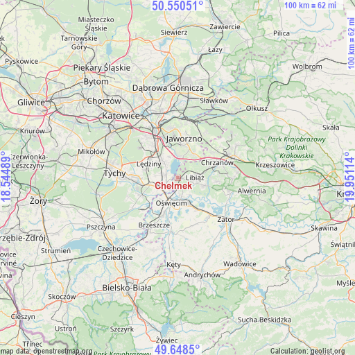
| Upper-left | 50.55051°, | 18.54489° |
| Center: | 50.10163°, | 19.24801° |
| Lower-right: | 49.6485°, | 19.95114° |
| Map W x H: | 100.3×100.3 km | = 62.3×62.3mi |
| max Lat: | 54.83135° ⇑77.8% North |
| Chełmek: | 50.10163° |
| min Lat: | ⇓22.2% South 49.21328° |
| min Long | Chełmek | max Long |
| 14.20249° | 19.24801° | 24.03723° |
| W 44.8%⇐ | ⇒55.2% E |
Elevation
Elevation of Chełmek is 249 m = 817 ft, and this is 57.6 m = 189 ft above average elevation for this country.
| Max E: |
974 m = 3196 ft | 24.2% |
| Chełmek | 249 m 817 ft | |
| Avg. | 191.4 m = 628 ft | |
Min E: |
-3 m = -10 ft | 75.8% |
See also: Poland elevation on elevation.city.
Geographical zone
Chełmek is located in North temperate zone (between Tropic of Cancer and the Arctic Circle). Distance of this North polar circle is 1830.4 km =1137.4 mi to North.| Distance of | km | miles | from Chełmek |
|---|---|---|---|
| North Pole | 4436.3 | 2756.6 | to North |
| Arctic Circle | 1830.4 | 1137.4 | to North |
| Tropic Cancer | 2964.9 | 1842.3 | to South |
| Equator | 5570.8 | 3461.5 | to South |


Nearby cities:
15 places around Chełmek: (largest is in red/bold)
• Babice
6.2 km =3.9 mi,  214°
214°
• Brzezinka
7.8 km =4.8 mi, 212°
• Chełm Śląski
3.8 km =2.4 mi,  281°
281°
• Harmęże
10.8 km =6.7 mi, 214°
• Imielin
6.6 km =4.1 mi,  317°
317°
• Libiąż
4.8 km =3 mi,  86°
86°
• Lędziny
9.5 km =5.9 mi,  298°
298°
• Mętków
10.6 km =6.6 mi,  121°
121°
• Oświęcim
7.9 km =4.9 mi,  199°
199°
• Poręba Wielka
10.4 km =6.5 mi,  165°
165°
• Rajsko
10.7 km =6.6 mi, 201°
• Włosienica
10.5 km =6.5 mi,  152°
152°
• Zaborze
8.9 km =5.5 mi,  183°
183°
• Zagórze
11.1 km =6.9 mi, 94°
• Żarki
7.7 km =4.8 mi,  105°
105°
Sources, notices
• [Note1] Compared only with cities in Poland existing in our database
• [Src1] Map data: © OpenStreetMap contributors (CC-BY-SA)
• [Src2] Other city data from geonames.org with taken over terms of usage.
• [Src3] Geographical zone / Annual Mean Temperature by Robert A. Rohde @ Wikipedia
