Cielmice geodata
Cielmice (Silesia) is a populated place; located in Poland in Europe/Warsaw (GMT+2) time zone. With population of 1,200 people, there are 2164 cities with bigger population in this country. Compared to other cities in Poland, 78.5% of cities are located further ↑North; 59.8% of cities are located further →East and 75.5% of cities have lower elevation than Cielmice. Note1


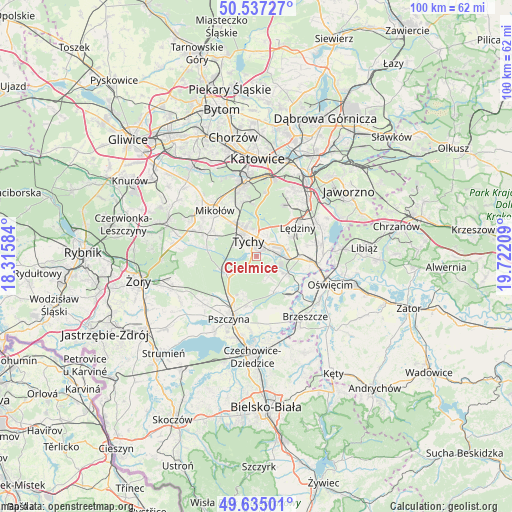
Cielmice GPS coordinates[2]
50° 5' 17.736" North, 19° 1' 8.256" East
| Map corner | latitude | longitude |
|---|---|---|
| Upper-left | 50.53727°, | 18.31584° |
| Center: | 50.08826°, | 19.01896° |
| Lower-right: | 49.63501°, | 19.72209° |
| Map W x H: | 100.3×100.3 km | = 62.3×62.3mi |
| max Lat: | 54.83135° ⇑78.5% North |
| Cielmice: | 50.08826° |
| min Lat: | ⇓21.5% South 49.21328° |
| min Long | Cielmice | max Long |
| 14.20249° | 19.01896° | 24.03723° |
| W 40.2%⇐ | ⇒59.8% E |
Elevation
Elevation of Cielmice is 248 m = 814 ft, and this is 56.6 m = 186 ft above average elevation for this country.
| Max E: |
974 m = 3196 ft | 24.5% |
| Cielmice | 248 m 814 ft | |
| Avg. | 191.4 m = 628 ft | |
Min E: |
-3 m = -10 ft | 75.5% |
See also: Poland elevation on elevation.city.
Geographical zone
Cielmice is located in North temperate zone (between Tropic of Cancer and the Arctic Circle). Distance of this North polar circle is 1831.9 km =1138.3 mi to North.| Distance of | km | miles | from Cielmice |
|---|---|---|---|
| North Pole | 4437.8 | 2757.5 | to North |
| Arctic Circle | 1831.9 | 1138.3 | to North |
| Tropic Cancer | 2963.4 | 1841.4 | to South |
| Equator | 5569.3 | 3460.6 | to South |


Nearby cities:
15 places around Cielmice: (largest is in red/bold)
• Bieruń
5.3 km =3.3 mi,  87°
87°
• Bojszowy
6.8 km =4.2 mi,  119°
119°
• Bojszowy Nowe
4.5 km =2.8 mi,  150°
150°
• Czarków
11.2 km =7 mi,  225°
225°
• Frydek
10.9 km =6.8 mi,  159°
159°
• Gilowice
11.7 km =7.3 mi, 151°
• Gostyń
9.9 km =6.2 mi,  280°
280°
• Jankowice
9.9 km =6.2 mi,  192°
192°
• Kobiór
6.7 km =4.2 mi,  243°
243°
• Lędziny
10 km =6.2 mi,  52°
52°
• Międzyrzecze
7.8 km =4.8 mi, 155°
• Piasek
10 km =6.2 mi,  210°
210°
• Tychy
6.6 km =4.1 mi,  325°
325°
• Wola
10.8 km =6.7 mi,  136°
136°
• Wyry
9.8 km =6.1 mi,  300°
300°
Sources, notices
• [Note1] Compared only with cities in Poland existing in our database
• [Src1] Map data: © OpenStreetMap contributors (CC-BY-SA)
• [Src2] Other city data from geonames.org with taken over terms of usage.
• [Src3] Geographical zone / Annual Mean Temperature by Robert A. Rohde @ Wikipedia
