Jaworzno geodata
Jaworzno (Silesia) is a seat of a second-order administrative division; located in Poland in Europe/Warsaw (GMT+2) time zone. With population of 96,541 people, there are 49 cities with bigger population in this country. Compared to other cities in Poland, 74.3% of cities are located further ↑North; 54.7% of cities are located further →East and 89.1% of cities have lower elevation than Jaworzno. Note1


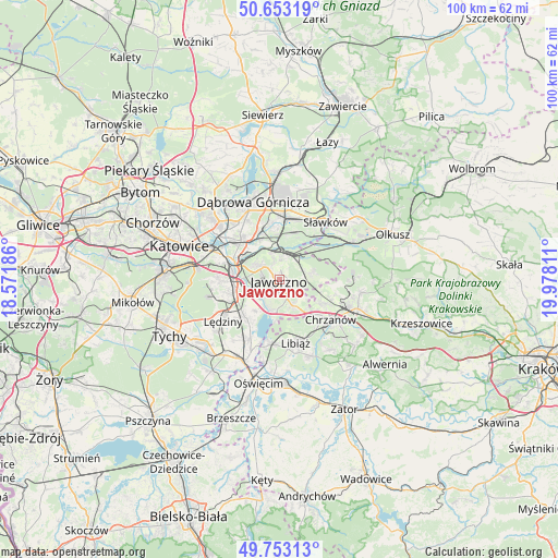
Jaworzno GPS coordinates[2]
50° 12' 19.008" North, 19° 16' 29.928" East
| Map corner | latitude | longitude |
|---|---|---|
| Upper-left | 50.65319°, | 18.57186° |
| Center: | 50.20528°, | 19.27498° |
| Lower-right: | 49.75313°, | 19.97811° |
| Map W x H: | 100.1×100.1 km | = 62.2×62.2mi |
| max Lat: | 54.83135° ⇑74.3% North |
| Jaworzno: | 50.20528° |
| min Lat: | ⇓25.7% South 49.21328° |
| min Long | Jaworzno | max Long |
| 14.20249° | 19.27498° | 24.03723° |
| W 45.3%⇐ | ⇒54.7% E |
Elevation
Elevation of Jaworzno is 318 m = 1043 ft, and this is 126.6 m = 415 ft above average elevation for this country.
| Max E: |
974 m = 3196 ft | 10.9% |
| Jaworzno | 318 m 1043 ft | |
| Avg. | 191.4 m = 628 ft | |
Min E: |
-3 m = -10 ft | 89.1% |
See also: Jaworzno elevation on elevation.city.
Geographical zone
Jaworzno is located in North temperate zone (between Tropic of Cancer and the Arctic Circle). Distance of this North polar circle is 1818.9 km =1130.2 mi to North.| Distance of | km | miles | from Jaworzno |
|---|---|---|---|
| North Pole | 4424.8 | 2749.4 | to North |
| Arctic Circle | 1818.9 | 1130.2 | to North |
| Tropic Cancer | 2976.4 | 1849.4 | to South |
| Equator | 5582.3 | 3468.7 | to South |


Nearby cities:
15 places around Jaworzno: (largest is in red/bold)
• Balin
8.8 km =5.5 mi,  118°
118°
• Bukowno
14.7 km =9.1 mi,  63°
63°
• Chełm Śląski
12.2 km =7.6 mi,  207°
207°
• Chełmek
11.7 km =7.3 mi,  189°
189°
• Chrzanów
11.9 km =7.4 mi,  130°
130°
• Imielin
9.2 km =5.7 mi,  223°
223°
• Libiąż
11.6 km =7.2 mi,  165°
165°
• Luszowice
9.8 km =6.1 mi,  110°
110°
• Lędziny
12.4 km =7.7 mi,  235°
235°
• Mysłowice
7.7 km =4.8 mi,  271°
271°
• Myślachowice
14.8 km =9.2 mi,  98°
98°
• Sosnowiec
15.2 km =9.4 mi,  306°
306°
• Sławków
13.3 km =8.3 mi,  37°
37°
• Trzebinia
14.8 km =9.2 mi, 110°
• Żarki
14.7 km =9.1 mi,  158°
158°
Sources, notices
• [Note1] Compared only with cities in Poland existing in our database
• [Src1] Map data: © OpenStreetMap contributors (CC-BY-SA)
• [Src2] Other city data from geonames.org with taken over terms of usage.
• [Src3] Geographical zone / Annual Mean Temperature by Robert A. Rohde @ Wikipedia
