Pozowice geodata
Pozowice (Lesser Poland) is a populated place; located in Poland in Europe/Warsaw (GMT+2) time zone. With population of 650 people, there are 3162 cities with bigger population in this country. Compared to other cities in Poland, 84.2% of cities are located further ↑North; 52.8% of cities are located further ←West and 62.8% of cities have lower elevation than Pozowice. Note1


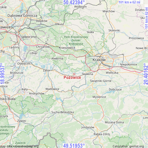
Pozowice GPS coordinates[2]
49° 58' 25.896" North, 19° 41' 54.564" East
| Map corner | latitude | longitude |
|---|---|---|
| Upper-left | 50.42394°, | 18.99537° |
| Center: | 49.97386°, | 19.69849° |
| Lower-right: | 49.51953°, | 20.40162° |
| Map W x H: | 100.6×100.6 km | = 62.5×62.5mi |
| max Lat: | 54.83135° ⇑84.2% North |
| Pozowice: | 49.97386° |
| min Lat: | ⇓15.8% South 49.21328° |
| min Long | Pozowice | max Long |
| 14.20249° | 19.69849° | 24.03723° |
| W 52.8%⇐ | ⇒47.2% E |
Elevation
Elevation of Pozowice is 208 m = 682 ft, and this is 16.6 m = 54 ft above average elevation for this country.
| Max E: |
974 m = 3196 ft | 37.2% |
| Pozowice | 208 m 682 ft | |
| Avg. | 191.4 m = 628 ft | |
Min E: |
-3 m = -10 ft | 62.8% |
See also: Poland elevation on elevation.city.
Geographical zone
Pozowice is located in North temperate zone (between Tropic of Cancer and the Arctic Circle). Distance of this North polar circle is 1844.6 km =1146.2 mi to North.| Distance of | km | miles | from Pozowice |
|---|---|---|---|
| North Pole | 4450.5 | 2765.4 | to North |
| Arctic Circle | 1844.6 | 1146.2 | to North |
| Tropic Cancer | 2950.7 | 1833.5 | to South |
| Equator | 5556.6 | 3452.7 | to South |


Nearby cities:
15 places around Pozowice: (largest is in red/bold)
• Borek Szlachecki
5.6 km =3.5 mi,  100°
100°
• Brzeźnica
5.7 km =3.5 mi,  260°
260°
• Bęczyn
5.1 km =3.2 mi,  212°
212°
• Czernichów
2.1 km =1.3 mi,  323°
323°
• Facimiech
1.7 km =1.1 mi,  117°
117°
• Jeziorzany
6 km =3.7 mi,  67°
67°
• Krzęcin
4.6 km =2.9 mi,  137°
137°
• Nowa Wieś Szlachecka
5.9 km =3.7 mi,  359°
359°
• Ochodza
3.3 km =2.1 mi,  105°
105°
• Paszkówka
4.2 km =2.6 mi,  200°
200°
• Przeginia Duchowna
6.1 km =3.8 mi,  328°
328°
• Przeginia Narodowa
4.9 km =3 mi, 325°
• Przytkowice
6.3 km =3.9 mi,  188°
188°
• Sosnowice
4 km =2.5 mi,  162°
162°
• Wołowice
2.6 km =1.6 mi,  50°
50°
Sources, notices
• [Note1] Compared only with cities in Poland existing in our database
• [Src1] Map data: © OpenStreetMap contributors (CC-BY-SA)
• [Src2] Other city data from geonames.org with taken over terms of usage.
• [Src3] Geographical zone / Annual Mean Temperature by Robert A. Rohde @ Wikipedia
