Kamienna Góra geodata
Kamienna Góra (Lower Silesia) is a seat of a third-order administrative division; located in Poland in Europe/Warsaw (GMT+2) time zone. With population of 21,743 people, there are 228 cities with bigger population in this country. Compared to other cities in Poland, 60.6% of cities are located further ↑North; 92.4% of cities are located further →East and 95.9% of cities have lower elevation than Kamienna Góra. Note1
Administrative division(s):
- Level 1: Lower Silesia
- Level 2: Powiat kamiennogórski
- Level 3: Kamienna Góra


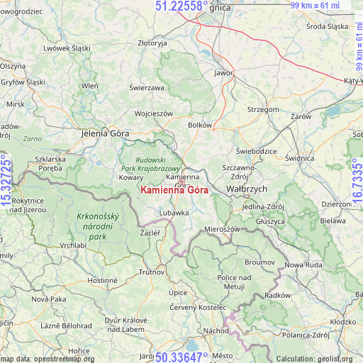
Kamienna Góra GPS coordinates[2]
50° 46' 59.304" North, 16° 1' 49.332" East
| Map corner | latitude | longitude |
|---|---|---|
| Upper-left | 51.22558°, | 15.32725° |
| Center: | 50.78314°, | 16.03037° |
| Lower-right: | 50.33647°, | 16.7335° |
| Map W x H: | 98.9×98.9 km | = 61.5×61.5mi |
| max Lat: | 54.83135° ⇑60.6% North |
| Kamienna Góra: | 50.78314° |
| min Lat: | ⇓39.4% South 49.21328° |
| min Long | Kamienna Góra | max Long |
| 14.20249° | 16.03037° | 24.03723° |
| W 7.6%⇐ | ⇒92.4% E |
Elevation
Elevation of Kamienna Góra is 443 m = 1453 ft, and this is 251.6 m = 825 ft above average elevation for this country.
| Max E: |
974 m = 3196 ft | 4.1% |
| Kamienna Góra | 443 m 1453 ft | |
| Avg. | 191.4 m = 628 ft | |
Min E: |
-3 m = -10 ft | 95.9% |
See also: Poland elevation on elevation.city.
Geographical zone
Kamienna Góra is located in North temperate zone (between Tropic of Cancer and the Arctic Circle). Distance of this North polar circle is 1754.6 km =1090.3 mi to North.| Distance of | km | miles | from Kamienna Góra |
|---|---|---|---|
| North Pole | 4360.5 | 2709.5 | to North |
| Arctic Circle | 1754.6 | 1090.3 | to North |
| Tropic Cancer | 3040.6 | 1889.3 | to South |
| Equator | 5646.6 | 3508.6 | to South |


Nearby cities:
15 places around Kamienna Góra: (largest is in red/bold)
• Boguszów-Gorce
12.7 km =7.9 mi,  104°
104°
• Bolków
16.2 km =10.1 mi,  17°
17°
• Czarny Bór
7.2 km =4.5 mi, 101°
• Janowice Wielkie
12.7 km =7.9 mi,  323°
323°
• Karpacz
19.3 km =12 mi,  267°
267°
• Kowary
13.7 km =8.5 mi, 274°
• Krzeszów
6.1 km =3.8 mi,  152°
152°
• Lubawka
9 km =5.6 mi,  193°
193°
• Marciszów
6.9 km =4.3 mi,  354°
354°
• Mieroszów
17.2 km =10.7 mi,  139°
139°
• Mysłakowice
18.8 km =11.7 mi,  290°
290°
• Stare Bogaczowice
13.5 km =8.4 mi,  57°
57°
• Szczawno-Zdrój
16.1 km =10 mi,  81°
81°
• Wałbrzych
17.9 km =11.1 mi,  94°
94°
• Wierzchosławice
12.8 km =8 mi, 19°
Sources, notices
• [Note1] Compared only with cities in Poland existing in our database
• [Src1] Map data: © OpenStreetMap contributors (CC-BY-SA)
• [Src2] Other city data from geonames.org with taken over terms of usage.
• [Src3] Geographical zone / Annual Mean Temperature by Robert A. Rohde @ Wikipedia
