Krzeszów geodata
Krzeszów (Lower Silesia) is a populated place; located in Poland in Europe/Warsaw (GMT+2) time zone. With population of 1,527 people, there are 1822 cities with bigger population in this country. Compared to other cities in Poland, 61.9% of cities are located further ↑North; 92.2% of cities are located further →East and 96.6% of cities have lower elevation than Krzeszów. Note1
Administrative division(s):
- Level 1: Lower Silesia
- Level 2: Powiat kamiennogórski
- Level 3: Kamienna Góra


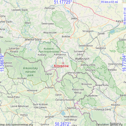
Krzeszów GPS coordinates[2]
50° 44' 3.624" North, 16° 4' 11.676" East
| Map corner | latitude | longitude |
|---|---|---|
| Upper-left | 51.17725°, | 15.36679° |
| Center: | 50.73434°, | 16.06991° |
| Lower-right: | 50.2872°, | 16.77304° |
| Map W x H: | 99×99 km | = 61.5×61.5mi |
| max Lat: | 54.83135° ⇑61.9% North |
| Krzeszów: | 50.73434° |
| min Lat: | ⇓38.1% South 49.21328° |
| min Long | Krzeszów | max Long |
| 14.20249° | 16.06991° | 24.03723° |
| W 7.8%⇐ | ⇒92.2% E |
Elevation
Elevation of Krzeszów is 462 m = 1516 ft, and this is 270.6 m = 888 ft above average elevation for this country.
| Max E: |
974 m = 3196 ft | 3.4% |
| Krzeszów | 462 m 1516 ft | |
| Avg. | 191.4 m = 628 ft | |
Min E: |
-3 m = -10 ft | 96.6% |
See also: Poland elevation on elevation.city.
Geographical zone
Krzeszów is located in North temperate zone (between Tropic of Cancer and the Arctic Circle). Distance of this North polar circle is 1760 km =1093.6 mi to North.| Distance of | km | miles | from Krzeszów |
|---|---|---|---|
| North Pole | 4365.9 | 2712.8 | to North |
| Arctic Circle | 1760 | 1093.6 | to North |
| Tropic Cancer | 3035.2 | 1886 | to South |
| Equator | 5641.1 | 3505.2 | to South |


Nearby cities:
15 places around Krzeszów: (largest is in red/bold)
• Boguszów-Gorce
9.8 km =6.1 mi,  76°
76°
• Bolków
21 km =13 mi,  5°
5°
• Czarny Bór
5.9 km =3.7 mi,  46°
46°
• Dziećmorowice
20.2 km =12.6 mi, 78°
• Janowice Wielkie
18.8 km =11.7 mi,  326°
326°
• Jedlina-Zdrój
19.5 km =12.1 mi,  94°
94°
• Kamienna Góra
6.1 km =3.8 mi, 332°
• Kowary
17.7 km =11 mi,  291°
291°
• Lubawka
5.9 km =3.7 mi,  235°
235°
• Marciszów
12.7 km =7.9 mi,  344°
344°
• Mieroszów
11.3 km =7 mi,  132°
132°
• Stare Bogaczowice
15.3 km =9.5 mi,  34°
34°
• Szczawno-Zdrój
15.2 km =9.4 mi,  59°
59°
• Wałbrzych
15.6 km =9.7 mi,  74°
74°
• Wierzchosławice
17.5 km =10.9 mi, 5°
Sources, notices
• [Note1] Compared only with cities in Poland existing in our database
• [Src1] Map data: © OpenStreetMap contributors (CC-BY-SA)
• [Src2] Other city data from geonames.org with taken over terms of usage.
• [Src3] Geographical zone / Annual Mean Temperature by Robert A. Rohde @ Wikipedia
