Zakrzewo geodata
Zakrzewo (Greater Poland) is a populated place; located in Poland in Europe/Warsaw (GMT+2) time zone. With population of 589 people, there are 3316 cities with bigger population in this country. Compared to other cities in Poland, 74.6% of cities are located further ↓South; 87.9% of cities are located further →East and 86.1% of cities have higher elevation than Zakrzewo. Note1


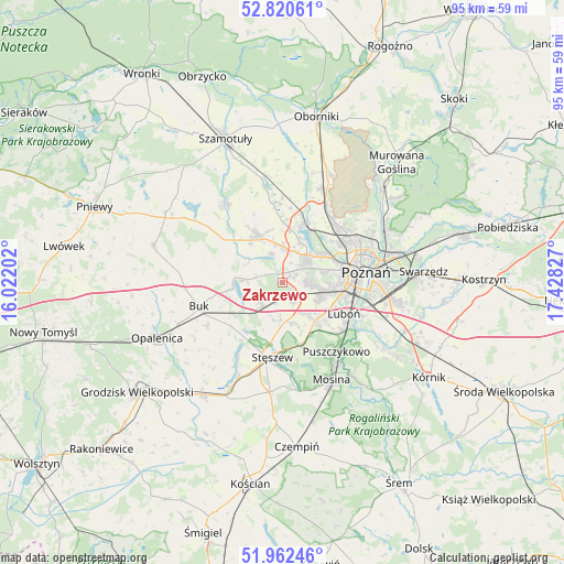
Zakrzewo GPS coordinates[2]
52° 23' 37.032" North, 16° 43' 30.504" East
| Map corner | latitude | longitude |
|---|---|---|
| Upper-left | 52.82061°, | 16.02202° |
| Center: | 52.39362°, | 16.72514° |
| Lower-right: | 51.96246°, | 17.42827° |
| Map W x H: | 95.4×95.4 km | = 59.3×59.3mi |
| max Lat: | 54.83135° ⇑25.4% North |
| Zakrzewo: | 52.39362° |
| min Lat: | ⇓74.6% South 49.21328° |
| min Long | Zakrzewo | max Long |
| 14.20249° | 16.72514° | 24.03723° |
| W 12.1%⇐ | ⇒87.9% E |
Elevation
Elevation of Zakrzewo is 87 m = 285 ft, and this is 104.4 m = 343 ft below average elevation for this country.
| Max E: |
974 m = 3196 ft | 86.1% |
| Avg. | 191.4 m = 628 ft | |
| Zakrzewo | 87 m = 285 ft | |
Min E: |
-3 m = -10 ft | 13.9% |
See also: Poland elevation on elevation.city.
Geographical zone
Zakrzewo is located in North temperate zone (between Tropic of Cancer and the Arctic Circle). Distance of this North polar circle is 1575.5 km =979 mi to North.| Distance of | km | miles | from Zakrzewo |
|---|---|---|---|
| North Pole | 4181.4 | 2598.2 | to North |
| Arctic Circle | 1575.5 | 979 | to North |
| Tropic Cancer | 3219.7 | 2000.6 | to South |
| Equator | 5825.6 | 3619.9 | to South |


Nearby cities:
15 places around Zakrzewo: (largest is in red/bold)
• Baranowo
6.2 km =3.9 mi,  41°
41°
• Buk
14.6 km =9.1 mi,  253°
253°
• Czapury
15.3 km =9.5 mi,  123°
123°
• Dopiewo
5.3 km =3.3 mi,  219°
219°
• Komorniki
8.4 km =5.2 mi,  136°
136°
• Luboń
12.5 km =7.8 mi,  114°
114°
• Plewiska
6.5 km =4 mi, 117°
• Poznań
14 km =8.7 mi,  83°
83°
• Puszczykowo
14.7 km =9.1 mi, 144°
• Rokietnica
13.3 km =8.3 mi,  6°
6°
• Stęszew
12.3 km =7.6 mi,  187°
187°
• Suchy Las
13.6 km =8.5 mi,  49°
49°
• Tarnowo Podgórne
9.1 km =5.7 mi,  332°
332°
• Złotniki
13.8 km =8.6 mi, 36°
• Łęczyca
13.9 km =8.6 mi,  133°
133°
Sources, notices
• [Note1] Compared only with cities in Poland existing in our database
• [Src1] Map data: © OpenStreetMap contributors (CC-BY-SA)
• [Src2] Other city data from geonames.org with taken over terms of usage.
• [Src3] Geographical zone / Annual Mean Temperature by Robert A. Rohde @ Wikipedia
