Baranowo geodata
Baranowo (Greater Poland) is a populated place; located in Poland in Europe/Warsaw (GMT+2) time zone. With population of 1,331 people, there are 2034 cities with bigger population in this country. Compared to other cities in Poland, 75.4% of cities are located further ↓South; 87.4% of cities are located further →East and 84.6% of cities have higher elevation than Baranowo. Note1
Administrative division(s):
- Level 1: Greater Poland
- Level 2: Powiat poznański
- Level 3: Tarnowo Podgórne


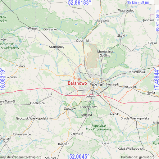
Baranowo GPS coordinates[2]
52° 26' 6.9" North, 16° 47' 10.716" East
| Map corner | latitude | longitude |
|---|---|---|
| Upper-left | 52.86183°, | 16.08319° |
| Center: | 52.43525°, | 16.78631° |
| Lower-right: | 52.0045°, | 17.48944° |
| Map W x H: | 95.3×95.3 km | = 59.2×59.2mi |
| max Lat: | 54.83135° ⇑24.6% North |
| Baranowo: | 52.43525° |
| min Lat: | ⇓75.4% South 49.21328° |
| min Long | Baranowo | max Long |
| 14.20249° | 16.78631° | 24.03723° |
| W 12.6%⇐ | ⇒87.4% E |
Elevation
Elevation of Baranowo is 90 m = 295 ft, and this is 101.4 m = 333 ft below average elevation for this country.
| Max E: |
974 m = 3196 ft | 84.6% |
| Avg. | 191.4 m = 628 ft | |
| Baranowo | 90 m = 295 ft | |
Min E: |
-3 m = -10 ft | 15.4% |
See also: Poland elevation on elevation.city.
Geographical zone
Baranowo is located in North temperate zone (between Tropic of Cancer and the Arctic Circle). Distance of this North polar circle is 1570.9 km =976.1 mi to North.| Distance of | km | miles | from Baranowo |
|---|---|---|---|
| North Pole | 4176.8 | 2595.3 | to North |
| Arctic Circle | 1570.9 | 976.1 | to North |
| Tropic Cancer | 3224.3 | 2003.5 | to South |
| Equator | 5830.3 | 3622.8 | to South |


Nearby cities:
15 places around Baranowo: (largest is in red/bold)
• Czapury
15.7 km =9.8 mi,  146°
146°
• Czerwonak
13.6 km =8.5 mi,  76°
76°
• Dopiewo
11.5 km =7.1 mi,  220°
220°
• Kaźmierz
16.2 km =10.1 mi,  302°
302°
• Komorniki
10.9 km =6.8 mi,  171°
171°
• Luboń
12.2 km =7.6 mi,  143°
143°
• Pamiątkowo
14.9 km =9.3 mi,  331°
331°
• Plewiska
7.7 km =4.8 mi, 168°
• Poznań
10.2 km =6.3 mi,  107°
107°
• Rokietnica
9 km =5.6 mi,  342°
342°
• Suchy Las
7.5 km =4.7 mi,  55°
55°
• Tarnowo Podgórne
9 km =5.6 mi,  292°
292°
• Zakrzewo
6.2 km =3.9 mi, 221°
• Złotniki
7.7 km =4.8 mi,  31°
31°
• Łęczyca
15.4 km =9.6 mi,  156°
156°
Sources, notices
• [Note1] Compared only with cities in Poland existing in our database
• [Src1] Map data: © OpenStreetMap contributors (CC-BY-SA)
• [Src2] Other city data from geonames.org with taken over terms of usage.
• [Src3] Geographical zone / Annual Mean Temperature by Robert A. Rohde @ Wikipedia
