Kobierzyce geodata
Kobierzyce (Lower Silesia) is a seat of a third-order administrative division; located in Poland in Europe/Warsaw (GMT+2) time zone. With population of 2,095 people, there are 1428 cities with bigger population in this country. Compared to other cities in Poland, 55.9% of cities are located further ↑North; 85.6% of cities are located further →East and 63.7% of cities have higher elevation than Kobierzyce. Note1


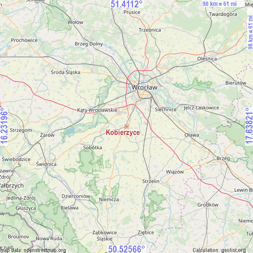
Kobierzyce GPS coordinates[2]
50° 58' 13.944" North, 16° 56' 6.288" East
| Map corner | latitude | longitude |
|---|---|---|
| Upper-left | 51.4112°, | 16.23196° |
| Center: | 50.97054°, | 16.93508° |
| Lower-right: | 50.52566°, | 17.63821° |
| Map W x H: | 98.5×98.5 km | = 61.2×61.2mi |
| max Lat: | 54.83135° ⇑55.9% North |
| Kobierzyce: | 50.97054° |
| min Lat: | ⇓44.1% South 49.21328° |
| min Long | Kobierzyce | max Long |
| 14.20249° | 16.93508° | 24.03723° |
| W 14.4%⇐ | ⇒85.6% E |
Elevation
Elevation of Kobierzyce is 137 m = 449 ft, and this is 54.4 m = 178 ft below average elevation for this country.
| Max E: |
974 m = 3196 ft | 63.7% |
| Avg. | 191.4 m = 628 ft | |
| Kobierzyce | 137 m = 449 ft | |
Min E: |
-3 m = -10 ft | 36.3% |
See also: Poland elevation on elevation.city.
Geographical zone
Kobierzyce is located in North temperate zone (between Tropic of Cancer and the Arctic Circle). Distance of this North polar circle is 1733.8 km =1077.3 mi to North.| Distance of | km | miles | from Kobierzyce |
|---|---|---|---|
| North Pole | 4339.7 | 2696.6 | to North |
| Arctic Circle | 1733.8 | 1077.3 | to North |
| Tropic Cancer | 3061.5 | 1902.3 | to South |
| Equator | 5667.4 | 3521.6 | to South |


Nearby cities:
15 places around Kobierzyce: (largest is in red/bold)
• Bielany Wrocławskie
7.6 km =4.7 mi,  17°
17°
• Borów
10.5 km =6.5 mi,  157°
157°
• Domasław
4.8 km =3 mi, 18°
• Gniechowice
7.4 km =4.6 mi,  285°
285°
• Grabiszynek
13.4 km =8.3 mi, 15°
• Jordanów Śląski
12.7 km =7.9 mi,  201°
201°
• Krzyki
11.9 km =7.4 mi, 20°
• Partynice
12.2 km =7.6 mi,  26°
26°
• Pietrzykowice
10.2 km =6.3 mi,  337°
337°
• Smolec
12 km =7.5 mi, 342°
• Tyniec Mały
5.5 km =3.4 mi,  349°
349°
• Wojszyce
12.4 km =7.7 mi,  38°
38°
• Węgry
8.7 km =5.4 mi,  122°
122°
• Żerniki Wrocławskie
11 km =6.8 mi,  50°
50°
• Żórawina
7.2 km =4.5 mi,  80°
80°
Sources, notices
• [Note1] Compared only with cities in Poland existing in our database
• [Src1] Map data: © OpenStreetMap contributors (CC-BY-SA)
• [Src2] Other city data from geonames.org with taken over terms of usage.
• [Src3] Geographical zone / Annual Mean Temperature by Robert A. Rohde @ Wikipedia
