Węgry geodata
Węgry (Lower Silesia) is a populated place; located in Poland in Europe/Warsaw (GMT+2) time zone. With population of 609 people, there are 3256 cities with bigger population in this country. Compared to other cities in Poland, 56.9% of cities are located further ↑North; 84.2% of cities are located further →East and 63% of cities have higher elevation than Węgry. Note1


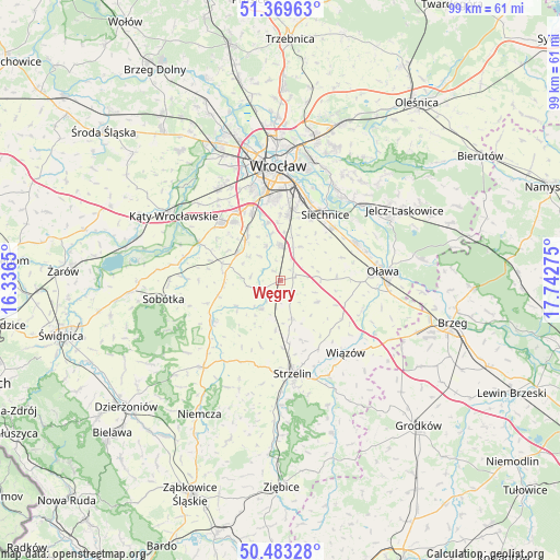
Węgry GPS coordinates[2]
50° 55' 42.852" North, 17° 2' 22.632" East
| Map corner | latitude | longitude |
|---|---|---|
| Upper-left | 51.36963°, | 16.3365° |
| Center: | 50.92857°, | 17.03962° |
| Lower-right: | 50.48328°, | 17.74275° |
| Map W x H: | 98.6×98.6 km | = 61.3×61.3mi |
| max Lat: | 54.83135° ⇑56.9% North |
| Węgry: | 50.92857° |
| min Lat: | ⇓43.1% South 49.21328° |
| min Long | Węgry | max Long |
| 14.20249° | 17.03962° | 24.03723° |
| W 15.8%⇐ | ⇒84.2% E |
Elevation
Elevation of Węgry is 139 m = 456 ft, and this is 52.4 m = 172 ft below average elevation for this country.
| Max E: |
974 m = 3196 ft | 63% |
| Avg. | 191.4 m = 628 ft | |
| Węgry | 139 m = 456 ft | |
Min E: |
-3 m = -10 ft | 37% |
See also: Poland elevation on elevation.city.
Geographical zone
Węgry is located in North temperate zone (between Tropic of Cancer and the Arctic Circle). Distance of this North polar circle is 1738.4 km =1080.2 mi to North.| Distance of | km | miles | from Węgry |
|---|---|---|---|
| North Pole | 4344.3 | 2699.4 | to North |
| Arctic Circle | 1738.4 | 1080.2 | to North |
| Tropic Cancer | 3056.8 | 1899.4 | to South |
| Equator | 5662.7 | 3518.6 | to South |


Nearby cities:
15 places around Węgry: (largest is in red/bold)
• Bielany Wrocławskie
13 km =8.1 mi,  337°
337°
• Borów
6.1 km =3.8 mi,  213°
213°
• Domaniów
7.4 km =4.6 mi,  121°
121°
• Domasław
10.9 km =6.8 mi,  327°
327°
• Jordanów Śląski
14 km =8.7 mi,  239°
239°
• Kobierzyce
8.7 km =5.4 mi,  302°
302°
• Partynice
15.6 km =9.7 mi,  353°
353°
• Radwanice
14.8 km =9.2 mi,  19°
19°
• Siechnice
13.9 km =8.6 mi,  32°
32°
• Tyniec Mały
13.1 km =8.1 mi,  320°
320°
• Wierzbno
9.9 km =6.2 mi,  84°
84°
• Wojszyce
14.4 km =8.9 mi,  1°
1°
• Święta Katarzyna
12 km =7.5 mi, 25°
• Żerniki Wrocławskie
11.7 km =7.3 mi,  5°
5°
• Żórawina
5.8 km =3.6 mi,  357°
357°
Sources, notices
• [Note1] Compared only with cities in Poland existing in our database
• [Src1] Map data: © OpenStreetMap contributors (CC-BY-SA)
• [Src2] Other city data from geonames.org with taken over terms of usage.
• [Src3] Geographical zone / Annual Mean Temperature by Robert A. Rohde @ Wikipedia
