Jordanów Śląski geodata
Jordanów Śląski (Lower Silesia) is a seat of a third-order administrative division; located in Poland in Europe/Warsaw (GMT+2) time zone. With population of 1,000 people, there are 2459 cities with bigger population in this country. Compared to other cities in Poland, 58.7% of cities are located further ↑North; 86.5% of cities are located further →East and 56.7% of cities have higher elevation than Jordanów Śląski. Note1
Administrative division(s):
- Level 1: Lower Silesia
- Level 2: Powiat wrocławski
- Level 3: Jordanów Śląski


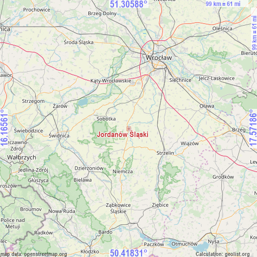
Jordanów Śląski GPS coordinates[2]
50° 51' 51.156" North, 16° 52' 7.428" East
| Map corner | latitude | longitude |
|---|---|---|
| Upper-left | 51.30588°, | 16.16561° |
| Center: | 50.86421°, | 16.86873° |
| Lower-right: | 50.41831°, | 17.57186° |
| Map W x H: | 98.7×98.7 km | = 61.3×61.3mi |
| max Lat: | 54.83135° ⇑58.7% North |
| Jordanów Śląski: | 50.86421° |
| min Lat: | ⇓41.3% South 49.21328° |
| min Long | Jordanów Ślą | max Long |
| 14.20249° | 16.86873° | 24.03723° |
| W 13.5%⇐ | ⇒86.5% E |
Elevation
Elevation of Jordanów Śląski is 154 m = 505 ft, and this is 37.4 m = 123 ft below average elevation for this country.
| Max E: |
974 m = 3196 ft | 56.7% |
| Avg. | 191.4 m = 628 ft | |
| Jordanów Śląski | 154 m = 505 ft | |
Min E: |
-3 m = -10 ft | 43.3% |
See also: Poland elevation on elevation.city.
Geographical zone
Jordanów Śląski is located in North temperate zone (between Tropic of Cancer and the Arctic Circle). Distance of this North polar circle is 1745.6 km =1084.7 mi to North.| Distance of | km | miles | from Jordanów Śląski |
|---|---|---|---|
| North Pole | 4351.5 | 2703.9 | to North |
| Arctic Circle | 1745.6 | 1084.7 | to North |
| Tropic Cancer | 3049.7 | 1895 | to South |
| Equator | 5655.6 | 3514.2 | to South |


Nearby cities:
15 places around Jordanów Śląski: (largest is in red/bold)
• Borów
8.9 km =5.5 mi,  76°
76°
• Dobrocin
18.4 km =11.4 mi,  218°
218°
• Domasław
17.5 km =10.9 mi,  20°
20°
• Gniechowice
14 km =8.7 mi,  349°
349°
• Kobierzyce
12.7 km =7.9 mi, 21°
• Kondratowice
11.1 km =6.9 mi,  155°
155°
• Niemcza
16.2 km =10.1 mi,  188°
188°
• Sobótka
9.6 km =6 mi,  294°
294°
• Strzelin
16.6 km =10.3 mi,  123°
123°
• Tyniec Mały
17.6 km =10.9 mi,  11°
11°
• Uciechów
17.9 km =11.1 mi,  227°
227°
• Wilków Wielki
12.4 km =7.7 mi, 186°
• Węgry
14 km =8.7 mi,  59°
59°
• Łagiewniki
8.3 km =5.2 mi, 191°
• Żórawina
17.5 km =10.9 mi,  42°
42°
Sources, notices
• [Note1] Compared only with cities in Poland existing in our database
• [Src1] Map data: © OpenStreetMap contributors (CC-BY-SA)
• [Src2] Other city data from geonames.org with taken over terms of usage.
• [Src3] Geographical zone / Annual Mean Temperature by Robert A. Rohde @ Wikipedia
