Kalety geodata
Kalety (Silesia) is a seat of a third-order administrative division; located in Poland in Europe/Warsaw (GMT+2) time zone. With population of 8,670 people, there are 492 cities with bigger population in this country. Compared to other cities in Poland, 66.2% of cities are located further ↑North; 62.1% of cities are located further →East and 81.2% of cities have lower elevation than Kalety. Note1


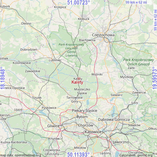
Kalety GPS coordinates[2]
50° 33' 45.72" North, 18° 53' 33.36" East
| Map corner | latitude | longitude |
|---|---|---|
| Upper-left | 51.00723°, | 18.18948° |
| Center: | 50.5627°, | 18.8926° |
| Lower-right: | 50.11393°, | 19.59573° |
| Map W x H: | 99.3×99.3 km | = 61.7×61.7mi |
| max Lat: | 54.83135° ⇑66.2% North |
| Kalety: | 50.5627° |
| min Lat: | ⇓33.8% South 49.21328° |
| min Long | Kalety | max Long |
| 14.20249° | 18.8926° | 24.03723° |
| W 37.9%⇐ | ⇒62.1% E |
Elevation
Elevation of Kalety is 271 m = 889 ft, and this is 79.6 m = 261 ft above average elevation for this country.
| Max E: |
974 m = 3196 ft | 18.8% |
| Kalety | 271 m 889 ft | |
| Avg. | 191.4 m = 628 ft | |
Min E: |
-3 m = -10 ft | 81.2% |
See also: Poland elevation on elevation.city.
Geographical zone
Kalety is located in North temperate zone (between Tropic of Cancer and the Arctic Circle). Distance of this North polar circle is 1779.1 km =1105.5 mi to North.| Distance of | km | miles | from Kalety |
|---|---|---|---|
| North Pole | 4385 | 2724.7 | to North |
| Arctic Circle | 1779.1 | 1105.5 | to North |
| Tropic Cancer | 3016.1 | 1874.1 | to South |
| Equator | 5622 | 3493.3 | to South |


Nearby cities:
15 places around Kalety: (largest is in red/bold)
• Boronów
12.5 km =7.8 mi,  4°
4°
• Kamienica
10.8 km =6.7 mi,  41°
41°
• Koszęcin
8.7 km =5.4 mi,  335°
335°
• Lubsza
8.9 km =5.5 mi,  58°
58°
• Miasteczko Śląskie
7.5 km =4.7 mi,  153°
153°
• Nakło
14 km =8.7 mi,  174°
174°
• Orzech
15.2 km =9.4 mi, 171°
• Ożarowice
15.5 km =9.6 mi,  136°
136°
• Psary
8 km =5 mi, 43°
• Starcza
15.4 km =9.6 mi, 43°
• Strzebiń
6 km =3.7 mi, 3°
• Tarnowskie Góry
13.2 km =8.2 mi,  189°
189°
• Tworóg
13 km =8.1 mi,  254°
254°
• Wożniki
12.2 km =7.6 mi,  75°
75°
• Świerklaniec
13.7 km =8.5 mi, 166°
Sources, notices
• [Note1] Compared only with cities in Poland existing in our database
• [Src1] Map data: © OpenStreetMap contributors (CC-BY-SA)
• [Src2] Other city data from geonames.org with taken over terms of usage.
• [Src3] Geographical zone / Annual Mean Temperature by Robert A. Rohde @ Wikipedia
