Tarnowskie Góry geodata
Tarnowskie Góry (Silesia) is a seat of a second-order administrative division; located in Poland in Europe/Warsaw (GMT+2) time zone. With population of 60,938 people, there are 84 cities with bigger population in this country. Compared to other cities in Poland, 68.3% of cities are located further ↑North; 62.5% of cities are located further →East and 86.2% of cities have lower elevation than Tarnowskie Góry. Note1


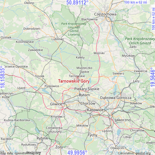
Tarnowskie Góry GPS coordinates[2]
50° 26' 43.728" North, 18° 51' 41.292" East
| Map corner | latitude | longitude |
|---|---|---|
| Upper-left | 50.89112°, | 18.15835° |
| Center: | 50.44548°, | 18.86147° |
| Lower-right: | 49.9956°, | 19.5646° |
| Map W x H: | 99.6×99.6 km | = 61.9×61.9mi |
| max Lat: | 54.83135° ⇑68.3% North |
| Tarnowskie Góry: | 50.44548° |
| min Lat: | ⇓31.7% South 49.21328° |
| min Long | Tarnowskie Gór | max Long |
| 14.20249° | 18.86147° | 24.03723° |
| W 37.5%⇐ | ⇒62.5% E |
Elevation
Elevation of Tarnowskie Góry is 297 m = 974 ft, and this is 105.6 m = 346 ft above average elevation for this country.
| Max E: |
974 m = 3196 ft | 13.8% |
| Tarnowskie Góry | 297 m 974 ft | |
| Avg. | 191.4 m = 628 ft | |
Min E: |
-3 m = -10 ft | 86.2% |
See also: Tarnowskie Góry elevation on elevation.city.
Geographical zone
Tarnowskie Góry is located in North temperate zone (between Tropic of Cancer and the Arctic Circle). Distance of this North polar circle is 1792.2 km =1113.6 mi to North.| Distance of | km | miles | from Tarnowskie Góry |
|---|---|---|---|
| North Pole | 4398.1 | 2732.9 | to North |
| Arctic Circle | 1792.2 | 1113.6 | to North |
| Tropic Cancer | 3003.1 | 1866 | to South |
| Equator | 5609 | 3485.3 | to South |


Nearby cities:
15 places around Tarnowskie Góry: (largest is in red/bold)
• Bobrowniki
11.5 km =7.1 mi,  129°
129°
• Bytom
12 km =7.5 mi,  154°
154°
• Dobieszowice
12 km =7.5 mi,  116°
116°
• Kalety
13.2 km =8.2 mi,  9°
9°
• Miasteczko Śląskie
8.4 km =5.2 mi,  40°
40°
• Nakło
3.6 km =2.2 mi,  105°
105°
• Orzech
4.8 km =3 mi, 114°
• Ożarowice
13 km =8.1 mi,  81°
81°
• Piekary Śląskie
8.6 km =5.3 mi, 147°
• Radzionków
5.8 km =3.6 mi, 150°
• Sączów
12 km =7.5 mi,  95°
95°
• Wieszowa
9.9 km =6.2 mi,  226°
226°
• Wymysłów
9.7 km =6 mi, 113°
• Zbrosławice
8.3 km =5.2 mi,  246°
246°
• Świerklaniec
5.4 km =3.4 mi,  93°
93°
Sources, notices
• [Note1] Compared only with cities in Poland existing in our database
• [Src1] Map data: © OpenStreetMap contributors (CC-BY-SA)
• [Src2] Other city data from geonames.org with taken over terms of usage.
• [Src3] Geographical zone / Annual Mean Temperature by Robert A. Rohde @ Wikipedia
