Miasteczko Śląskie geodata
Miasteczko Śląskie (Silesia) is a section of populated place; located in Poland in Europe/Warsaw (GMT+2) time zone. With population of 7,327 people, there are 524 cities with bigger population in this country. Compared to other cities in Poland, 67.3% of cities are located further ↑North; 61.1% of cities are located further →East and 87.1% of cities have lower elevation than Miasteczko Śląskie. Note1
Administrative division(s):
- Level 1: Silesia
- Level 2: Powiat tarnogórski
- Level 3: Miasteczko Śląskie


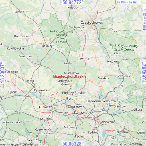
Miasteczko Śląskie GPS coordinates[2]
50° 30' 9.432" North, 18° 56' 22.164" East
| Map corner | latitude | longitude |
|---|---|---|
| Upper-left | 50.94772°, | 18.23637° |
| Center: | 50.50262°, | 18.93949° |
| Lower-right: | 50.05328°, | 19.64262° |
| Map W x H: | 99.5×99.5 km | = 61.8×61.8mi |
| max Lat: | 54.83135° ⇑67.3% North |
| Miasteczko Śląskie: | 50.50262° |
| min Lat: | ⇓32.7% South 49.21328° |
| min Long | Miasteczko Śl� | max Long |
| 14.20249° | 18.93949° | 24.03723° |
| W 38.9%⇐ | ⇒61.1% E |
Elevation
Elevation of Miasteczko Śląskie is 301 m = 988 ft, and this is 109.6 m = 360 ft above average elevation for this country.
| Max E: |
974 m = 3196 ft | 12.9% |
| Miasteczko Śląskie | 301 m 988 ft | |
| Avg. | 191.4 m = 628 ft | |
Min E: |
-3 m = -10 ft | 87.1% |
See also: Poland elevation on elevation.city.
Geographical zone
Miasteczko Śląskie is located in North temperate zone (between Tropic of Cancer and the Arctic Circle). Distance of this North polar circle is 1785.8 km =1109.6 mi to North.| Distance of | km | miles | from Miasteczko Śląskie |
|---|---|---|---|
| North Pole | 4391.7 | 2728.9 | to North |
| Arctic Circle | 1785.8 | 1109.6 | to North |
| Tropic Cancer | 3009.4 | 1870 | to South |
| Equator | 5615.4 | 3489.2 | to South |


Nearby cities:
15 places around Miasteczko Śląskie: (largest is in red/bold)
• Dobieszowice
12.8 km =8 mi,  156°
156°
• Kalety
7.5 km =4.7 mi,  333°
333°
• Lubsza
12.1 km =7.5 mi,  20°
20°
• Nakło
7.6 km =4.7 mi,  195°
195°
• Orzech
8.4 km =5.2 mi,  188°
188°
• Ożarowice
8.6 km =5.3 mi,  121°
121°
• Piekary Śląskie
13.6 km =8.5 mi,  183°
183°
• Psary
12.6 km =7.8 mi,  9°
9°
• Radzionków
11.7 km =7.3 mi, 193°
• Strzebiń
13 km =8.1 mi,  346°
346°
• Sączów
9.9 km =6.2 mi,  139°
139°
• Tarnowskie Góry
8.4 km =5.2 mi,  220°
220°
• Wożniki
12.9 km =8 mi,  41°
41°
• Wymysłów
10.7 km =6.6 mi, 161°
• Świerklaniec
6.7 km =4.2 mi, 181°
Sources, notices
• [Note1] Compared only with cities in Poland existing in our database
• [Src1] Map data: © OpenStreetMap contributors (CC-BY-SA)
• [Src2] Other city data from geonames.org with taken over terms of usage.
• [Src3] Geographical zone / Annual Mean Temperature by Robert A. Rohde @ Wikipedia
