Tworóg geodata
Tworóg (Silesia) is a seat of a third-order administrative division; located in Poland in Europe/Warsaw (GMT+2) time zone. With population of 3,607 people, there are 891 cities with bigger population in this country. Compared to other cities in Poland, 66.7% of cities are located further ↑North; 64.9% of cities are located further →East and 75.5% of cities have lower elevation than Tworóg. Note1


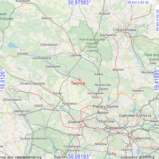
Tworóg GPS coordinates[2]
50° 31' 51.6" North, 18° 42' 56.592" East
| Map corner | latitude | longitude |
|---|---|---|
| Upper-left | 50.97583°, | 18.0126° |
| Center: | 50.531°, | 18.71572° |
| Lower-right: | 50.08193°, | 19.41885° |
| Map W x H: | 99.4×99.4 km | = 61.8×61.8mi |
| max Lat: | 54.83135° ⇑66.7% North |
| Tworóg: | 50.531° |
| min Lat: | ⇓33.3% South 49.21328° |
| min Long | Tworóg | max Long |
| 14.20249° | 18.71572° | 24.03723° |
| W 35.1%⇐ | ⇒64.9% E |
Elevation
Elevation of Tworóg is 248 m = 814 ft, and this is 56.6 m = 186 ft above average elevation for this country.
| Max E: |
974 m = 3196 ft | 24.5% |
| Tworóg | 248 m 814 ft | |
| Avg. | 191.4 m = 628 ft | |
Min E: |
-3 m = -10 ft | 75.5% |
See also: Poland elevation on elevation.city.
Geographical zone
Tworóg is located in North temperate zone (between Tropic of Cancer and the Arctic Circle). Distance of this North polar circle is 1782.7 km =1107.7 mi to North.| Distance of | km | miles | from Tworóg |
|---|---|---|---|
| North Pole | 4388.5 | 2726.9 | to North |
| Arctic Circle | 1782.7 | 1107.7 | to North |
| Tropic Cancer | 3012.6 | 1871.9 | to South |
| Equator | 5618.5 | 3491.2 | to South |


Nearby cities:
15 places around Tworóg: (largest is in red/bold)
• Kalety
13 km =8.1 mi,  74°
74°
• Koszęcin
14.5 km =9 mi,  37°
37°
• Krupski Młyn
8.1 km =5 mi,  305°
305°
• Lubliniec
15.5 km =9.6 mi,  351°
351°
• Miasteczko Śląskie
16.1 km =10 mi,  101°
101°
• Nakło
17.3 km =10.7 mi,  127°
127°
• Pyskowice
15.7 km =9.8 mi,  201°
201°
• Strzebiń
16 km =9.9 mi,  53°
53°
• Tarnowskie Góry
14 km =8.7 mi, 132°
• Toszek
16.1 km =10 mi,  238°
238°
• Wielowieś
7.4 km =4.6 mi,  251°
251°
• Wieszowa
16.6 km =10.3 mi,  169°
169°
• Zawadzkie
18.3 km =11.4 mi,  296°
296°
• Zbrosławice
13.1 km =8.1 mi, 167°
• Świerklaniec
18.5 km =11.5 mi,  122°
122°
Sources, notices
• [Note1] Compared only with cities in Poland existing in our database
• [Src1] Map data: © OpenStreetMap contributors (CC-BY-SA)
• [Src2] Other city data from geonames.org with taken over terms of usage.
• [Src3] Geographical zone / Annual Mean Temperature by Robert A. Rohde @ Wikipedia
